Mera geodata
Mera (Vrancea) is a seat of a second-order administrative division; located in Romania in Europe/Bucharest (GMT+3) time zone. With population of 3,938 people, there are 1191 cities with bigger population in this country. Compared to other cities in Romania, 50.6% of cities are located further ↑North; 82.1% of cities are located further ←West and 51.3% of cities have lower elevation than Mera. Note1


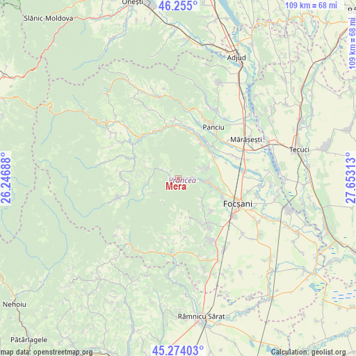
Mera GPS coordinates[2]
45° 46' 0.012" North, 26° 57' 0" East
| Map corner | latitude | longitude |
|---|---|---|
| Upper-left | 46.255°, | 26.24688° |
| Center: | 45.76667°, | 26.95° |
| Lower-right: | 45.27403°, | 27.65313° |
| Map W x H: | 109.1×109.1 km | = 67.8×67.8mi |
| max Lat: | 48.23793° ⇑50.6% North |
| Mera: | 45.76667° |
| min Lat: | ⇓49.4% South 43.65638° |
| min Long | Mera | max Long |
| 20.31667° | 26.95° | 29.65403° |
| W 82.1%⇐ | ⇒17.9% E |
Elevation
Elevation of Mera is 218 m = 715 ft, and this is 36.9 m = 121 ft below average elevation for this country.
| Max E: |
1278 m = 4193 ft | 48.7% |
| Avg. | 254.9 m = 836 ft | |
| Mera | 218 m = 715 ft | |
Min E: |
-2 m = -7 ft | 51.3% |
See also: Romania elevation on elevation.city.
Geographical zone
Mera is located in North temperate zone (between Tropic of Cancer and the Arctic Circle). Distance of this North polar circle is 2312.4 km =1436.9 mi to North.| Distance of | km | miles | from Mera |
|---|---|---|---|
| North Pole | 4918.3 | 3056.1 | to North |
| Arctic Circle | 2312.4 | 1436.9 | to North |
| Tropic Cancer | 2482.9 | 1542.8 | to South |
| Equator | 5088.8 | 3162 | to South |


Nearby cities:
15 places around Mera: (largest is in red/bold)
• Andreiaşu de Jos
9.2 km =5.7 mi,  258°
258°
• Boloteşti
11.7 km =7.3 mi,  50°
50°
• Broşteni
6.7 km =4.2 mi,  105°
105°
• Dălhăuți
11.3 km =7 mi,  137°
137°
• Faraoanele
9.6 km =6 mi,  127°
127°
• Jariştea
9.2 km =5.7 mi,  78°
78°
• Odobeşti
7.8 km =4.8 mi,  90°
90°
• Pitulușa
5 km =3.1 mi, 88°
• Pădureni
7.3 km =4.5 mi,  65°
65°
• Reghiu
9.2 km =5.7 mi,  281°
281°
• Răchitașu
11.5 km =7.1 mi,  250°
250°
• Vulcăneasa
3.2 km =2 mi, 284°
• Vârteşcoiu
11 km =6.8 mi, 109°
• Vărsătura
7.7 km =4.8 mi, 71°
• Șindrilari
6.1 km =3.8 mi,  296°
296°
Sources, notices
• [Note1] Compared only with cities in Romania existing in our database
• [Src1] Map data: © OpenStreetMap contributors (CC-BY-SA)
• [Src2] Other city data from geonames.org with taken over terms of usage.
• [Src3] Geographical zone / Annual Mean Temperature by Robert A. Rohde @ Wikipedia
