Perișoru geodata
Perișoru (Brăila) is a populated place; located in Romania in Europe/Bucharest (GMT+3) time zone. With population of 1,125 people, there are 3919 cities with bigger population in this country. Compared to other cities in Romania, 65% of cities are located further ↑North; 90.8% of cities are located further ←West and 96.6% of cities have higher elevation than Perișoru. Note1


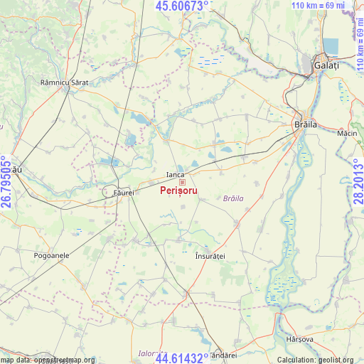
Perișoru GPS coordinates[2]
45° 6' 45.648" North, 27° 29' 53.412" East
| Map corner | latitude | longitude |
|---|---|---|
| Upper-left | 45.60673°, | 26.79505° |
| Center: | 45.11268°, | 27.49817° |
| Lower-right: | 44.61432°, | 28.2013° |
| Map W x H: | 110.3×110.3 km | = 68.5×68.5mi |
| max Lat: | 48.23793° ⇑65% North |
| Perișoru: | 45.11268° |
| min Lat: | ⇓35% South 43.65638° |
| min Long | Perișoru | max Long |
| 20.31667° | 27.49817° | 29.65403° |
| W 90.8%⇐ | ⇒9.2% E |
Elevation
Elevation of Perișoru is 26 m = 85 ft, and this is 228.9 m = 751 ft below average elevation for this country.
| Max E: |
1278 m = 4193 ft | 96.6% |
| Avg. | 254.9 m = 836 ft | |
| Perișoru | 26 m = 85 ft | |
Min E: |
-2 m = -7 ft | 3.4% |
See also: Romania elevation on elevation.city.
Geographical zone
Perișoru is located in North temperate zone (between Tropic of Cancer and the Arctic Circle). Distance of this North polar circle is 2385.1 km =1482 mi to North.| Distance of | km | miles | from Perișoru |
|---|---|---|---|
| North Pole | 4991 | 3101.3 | to North |
| Arctic Circle | 2385.1 | 1482 | to North |
| Tropic Cancer | 2410.1 | 1497.6 | to South |
| Equator | 5016.1 | 3116.9 | to South |


Nearby cities:
15 places around Perișoru: (largest is in red/bold)
• Batogu
13.9 km =8.6 mi,  202°
202°
• Bordei Verde
6.3 km =3.9 mi,  121°
121°
• Constantin Gabrielescu
11.9 km =7.4 mi,  112°
112°
• Dedulești
9.4 km =5.8 mi,  293°
293°
• Filipești
11.8 km =7.3 mi,  270°
270°
• Ianca
4.4 km =2.7 mi,  301°
301°
• Lișcoteanca
12.8 km =8 mi,  160°
160°
• Mircea Vodă
9 km =5.6 mi, 272°
• Oprișenești
4.8 km =3 mi,  55°
55°
• Plopu
4.2 km =2.6 mi,  17°
17°
• Surdila-Găiseanca
13.9 km =8.6 mi,  248°
248°
• Târlele Filiu
7.4 km =4.6 mi,  179°
179°
• Urleasca
12 km =7.5 mi,  77°
77°
• Şuţeşti
12.6 km =7.8 mi,  336°
336°
• Țepeș Vodă
11.7 km =7.3 mi, 56°
Sources, notices
• [Note1] Compared only with cities in Romania existing in our database
• [Src1] Map data: © OpenStreetMap contributors (CC-BY-SA)
• [Src2] Other city data from geonames.org with taken over terms of usage.
• [Src3] Geographical zone / Annual Mean Temperature by Robert A. Rohde @ Wikipedia
