Perişani geodata
Perişani (Vâlcea) is a seat of a second-order administrative division; located in Romania in Europe/Bucharest (GMT+3) time zone. With population of 3,781 people, there are 1276 cities with bigger population in this country. Compared to other cities in Romania, 57.4% of cities are located further ↑North; 61.8% of cities are located further →East and 93.5% of cities have lower elevation than Perişani. Note1


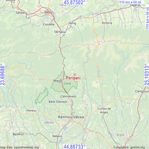
Perişani GPS coordinates[2]
45° 22' 59.988" North, 24° 24' 0" East
| Map corner | latitude | longitude |
|---|---|---|
| Upper-left | 45.87502°, | 23.69688° |
| Center: | 45.38333°, | 24.4° |
| Lower-right: | 44.88733°, | 25.10313° |
| Map W x H: | 109.8×109.8 km | = 68.2×68.2mi |
| max Lat: | 48.23793° ⇑57.4% North |
| Perişani: | 45.38333° |
| min Lat: | ⇓42.6% South 43.65638° |
| min Long | Perişani | max Long |
| 20.31667° | 24.4° | 29.65403° |
| W 38.2%⇐ | ⇒61.8% E |
Elevation
Elevation of Perişani is 582 m = 1909 ft, and this is 327.1 m = 1073 ft above average elevation for this country.
| Max E: |
1278 m = 4193 ft | 6.5% |
| Perişani | 582 m 1909 ft | |
| Avg. | 254.9 m = 836 ft | |
Min E: |
-2 m = -7 ft | 93.5% |
See also: Romania elevation on elevation.city.
Geographical zone
Perişani is located in North temperate zone (between Tropic of Cancer and the Arctic Circle). Distance of this North polar circle is 2355 km =1463.3 mi to North.| Distance of | km | miles | from Perişani |
|---|---|---|---|
| North Pole | 4960.9 | 3082.6 | to North |
| Arctic Circle | 2355 | 1463.3 | to North |
| Tropic Cancer | 2440.2 | 1516.3 | to South |
| Equator | 5046.2 | 3135.6 | to South |


Nearby cities:
15 places around Perişani: (largest is in red/bold)
• Boişoara
5.7 km =3.5 mi,  346°
346°
• Brezoi
12.9 km =8 mi,  246°
246°
• Bumbuești
6.1 km =3.8 mi,  331°
331°
• Câinenii Mici
13.6 km =8.5 mi,  324°
324°
• Călinești
8.5 km =5.3 mi,  259°
259°
• Greblești
12.3 km =7.6 mi, 326°
• Găujani
8 km =5 mi, 346°
• Mlăceni
2.8 km =1.7 mi,  86°
86°
• Racoviţa
7.5 km =4.7 mi,  299°
299°
• Rădăcinești
12.1 km =7.5 mi,  163°
163°
• Scăueni
13.7 km =8.5 mi,  165°
165°
• Spinu
0.9 km =0.6 mi,  20°
20°
• Sălătrucu
10.7 km =6.6 mi,  121°
121°
• Titești
4.1 km =2.5 mi, 352°
• Șerbănești
12.4 km =7.7 mi,  192°
192°
Sources, notices
• [Note1] Compared only with cities in Romania existing in our database
• [Src1] Map data: © OpenStreetMap contributors (CC-BY-SA)
• [Src2] Other city data from geonames.org with taken over terms of usage.
• [Src3] Geographical zone / Annual Mean Temperature by Robert A. Rohde @ Wikipedia
