Brezoi geodata
Brezoi (Vâlcea) is a seat of a second-order administrative division; located in Romania in Europe/Bucharest (GMT+3) time zone. With population of 6,668 people, there are 448 cities with bigger population in this country. Compared to other cities in Romania, 58% of cities are located further ↑North; 65.1% of cities are located further →East and 69.6% of cities have lower elevation than Brezoi. Note1


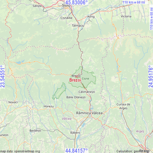
Brezoi GPS coordinates[2]
45° 20' 16.692" North, 24° 14' 55.068" East
| Map corner | latitude | longitude |
|---|---|---|
| Upper-left | 45.83006°, | 23.54551° |
| Center: | 45.33797°, | 24.24863° |
| Lower-right: | 44.84157°, | 24.95176° |
| Map W x H: | 109.9×109.9 km | = 68.3×68.3mi |
| max Lat: | 48.23793° ⇑58% North |
| Brezoi: | 45.33797° |
| min Lat: | ⇓42% South 43.65638° |
| min Long | Brezoi | max Long |
| 20.31667° | 24.24863° | 29.65403° |
| W 34.9%⇐ | ⇒65.1% E |
Elevation
Elevation of Brezoi is 317 m = 1040 ft, and this is 62.1 m = 204 ft above average elevation for this country.
| Max E: |
1278 m = 4193 ft | 30.4% |
| Brezoi | 317 m 1040 ft | |
| Avg. | 254.9 m = 836 ft | |
Min E: |
-2 m = -7 ft | 69.6% |
See also: Romania elevation on elevation.city.
Geographical zone
Brezoi is located in North temperate zone (between Tropic of Cancer and the Arctic Circle). Distance of this North polar circle is 2360.1 km =1466.5 mi to North.| Distance of | km | miles | from Brezoi |
|---|---|---|---|
| North Pole | 4966 | 3085.7 | to North |
| Arctic Circle | 2360.1 | 1466.5 | to North |
| Tropic Cancer | 2435.2 | 1513.2 | to South |
| Equator | 5041.1 | 3132.4 | to South |


Nearby cities:
15 places around Brezoi: (largest is in red/bold)
• Boişoara
14.9 km =9.3 mi,  44°
44°
• Bumbuești
13.7 km =8.5 mi, 40°
• Băile Olăneşti
15.4 km =9.6 mi,  184°
184°
• Călimăneşti
13.4 km =8.3 mi,  150°
150°
• Călinești
4.9 km =3 mi, 44°
• Jiblea Nouă
15.4 km =9.6 mi, 146°
• Jiblea Veche
13.2 km =8.2 mi,  142°
142°
• Livadia
14.7 km =9.1 mi, 182°
• Muereasca de Sus
15.5 km =9.6 mi,  166°
166°
• Perişani
12.9 km =8 mi,  66°
66°
• Racoviţa
10.2 km =6.3 mi,  31°
31°
• Spinu
13.5 km =8.4 mi,  64°
64°
• Sălătrucel
14.4 km =8.9 mi,  132°
132°
• Titești
14.5 km =9 mi,  51°
51°
• Șerbănești
11.6 km =7.2 mi, 127°
Sources, notices
• [Note1] Compared only with cities in Romania existing in our database
• [Src1] Map data: © OpenStreetMap contributors (CC-BY-SA)
• [Src2] Other city data from geonames.org with taken over terms of usage.
• [Src3] Geographical zone / Annual Mean Temperature by Robert A. Rohde @ Wikipedia
