Păuneşti geodata
Păuneşti (Vrancea) is a seat of a second-order administrative division; located in Romania in Europe/Bucharest (GMT+3) time zone. With population of 6,778 people, there are 430 cities with bigger population in this country. Compared to other cities in Romania, 55.7% of cities are located further ↓South; 85.1% of cities are located further ←West and 59.5% of cities have lower elevation than Păuneşti. Note1


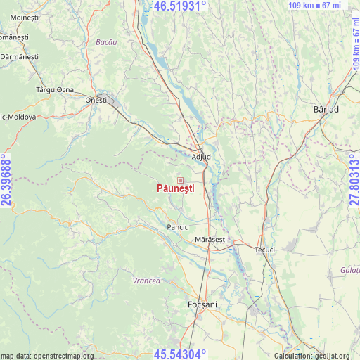
Păuneşti GPS coordinates[2]
46° 1' 59.988" North, 27° 6' 0" East
| Map corner | latitude | longitude |
|---|---|---|
| Upper-left | 46.51931°, | 26.39688° |
| Center: | 46.03333°, | 27.1° |
| Lower-right: | 45.54304°, | 27.80313° |
| Map W x H: | 108.6×108.6 km | = 67.5×67.5mi |
| max Lat: | 48.23793° ⇑44.3% North |
| Păuneşti: | 46.03333° |
| min Lat: | ⇓55.7% South 43.65638° |
| min Long | Păuneşti | max Long |
| 20.31667° | 27.1° | 29.65403° |
| W 85.1%⇐ | ⇒14.9% E |
Elevation
Elevation of Păuneşti is 261 m = 856 ft, and this is 6.1 m = 20 ft above average elevation for this country.
| Max E: |
1278 m = 4193 ft | 40.5% |
| Păuneşti | 261 m 856 ft | |
| Avg. | 254.9 m = 836 ft | |
Min E: |
-2 m = -7 ft | 59.5% |
See also: Romania elevation on elevation.city.
Geographical zone
Păuneşti is located in North temperate zone (between Tropic of Cancer and the Arctic Circle). Distance of this North polar circle is 2282.7 km =1418.4 mi to North.| Distance of | km | miles | from Păuneşti |
|---|---|---|---|
| North Pole | 4888.6 | 3037.6 | to North |
| Arctic Circle | 2282.7 | 1418.4 | to North |
| Tropic Cancer | 2512.5 | 1561.2 | to South |
| Equator | 5118.4 | 3180.4 | to South |


Nearby cities:
15 places around Păuneşti: (largest is in red/bold)
• Adjud
9 km =5.6 mi,  34°
34°
• Anghelești
5.7 km =3.5 mi,  331°
331°
• Burcioaia
10.9 km =6.8 mi,  67°
67°
• Ciorani
10.3 km =6.4 mi,  119°
119°
• Copăcești
6.6 km =4.1 mi,  13°
13°
• Domnești-Târg
6.7 km =4.2 mi,  106°
106°
• Fitioneşti
6.8 km =4.2 mi,  214°
214°
• Moviliţa
9.3 km =5.8 mi,  180°
180°
• Muncelu
10.5 km =6.5 mi, 210°
• Pufeşti
8.6 km =5.3 mi, 115°
• Rugineşti
3.9 km =2.4 mi,  19°
19°
• Slobozia
8.9 km =5.5 mi, 9°
• Urecheşti
11.2 km =7 mi,  353°
353°
• Viișoara
2.1 km =1.3 mi, 351°
• Văleni
6.2 km =3.9 mi,  46°
46°
Sources, notices
• [Note1] Compared only with cities in Romania existing in our database
• [Src1] Map data: © OpenStreetMap contributors (CC-BY-SA)
• [Src2] Other city data from geonames.org with taken over terms of usage.
• [Src3] Geographical zone / Annual Mean Temperature by Robert A. Rohde @ Wikipedia
