Păncești geodata
Păncești (Bacău) is a populated place; located in Romania in Europe/Bucharest (GMT+3) time zone. With population of 2,998 people, there are 1763 cities with bigger population in this country. Compared to other cities in Romania, 59.8% of cities are located further ↓South; 84.4% of cities are located further ←West and 53.5% of cities have higher elevation than Păncești. Note1


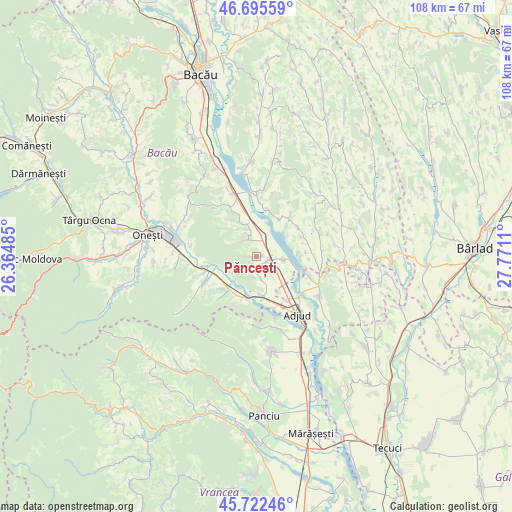
Păncești GPS coordinates[2]
46° 12' 40.248" North, 27° 4' 4.692" East
| Map corner | latitude | longitude |
|---|---|---|
| Upper-left | 46.69559°, | 26.36485° |
| Center: | 46.21118°, | 27.06797° |
| Lower-right: | 45.72246°, | 27.7711° |
| Map W x H: | 108.2×108.2 km | = 67.2×67.2mi |
| max Lat: | 48.23793° ⇑40.2% North |
| Păncești: | 46.21118° |
| min Lat: | ⇓59.8% South 43.65638° |
| min Long | Păncești | max Long |
| 20.31667° | 27.06797° | 29.65403° |
| W 84.4%⇐ | ⇒15.6% E |
Elevation
Elevation of Păncești is 194 m = 636 ft, and this is 60.9 m = 200 ft below average elevation for this country.
| Max E: |
1278 m = 4193 ft | 53.5% |
| Avg. | 254.9 m = 836 ft | |
| Păncești | 194 m = 636 ft | |
Min E: |
-2 m = -7 ft | 46.5% |
See also: Romania elevation on elevation.city.
Geographical zone
Păncești is located in North temperate zone (between Tropic of Cancer and the Arctic Circle). Distance of this North polar circle is 2263 km =1406.2 mi to North.| Distance of | km | miles | from Păncești |
|---|---|---|---|
| North Pole | 4868.9 | 3025.4 | to North |
| Arctic Circle | 2263 | 1406.2 | to North |
| Tropic Cancer | 2532.3 | 1573.5 | to South |
| Equator | 5138.2 | 3192.7 | to South |


Nearby cities:
15 places around Păncești: (largest is in red/bold)
• Berești
6 km =3.7 mi,  98°
98°
• Borșani
9.7 km =6 mi,  225°
225°
• Conțești
5.2 km =3.2 mi,  165°
165°
• Cornii de Sus
8.9 km =5.5 mi,  85°
85°
• Cornățel
9.1 km =5.7 mi,  191°
191°
• Coţofăneşti
9.4 km =5.8 mi,  223°
223°
• Cucova
5.1 km =3.2 mi,  339°
339°
• Orbeni
8.9 km =5.5 mi,  333°
333°
• Sascut
2.8 km =1.7 mi,  116°
116°
• Sascut-Sat
2.7 km =1.7 mi,  179°
179°
• Schineni
3.3 km =2.1 mi,  126°
126°
• Scurta
6.9 km =4.3 mi,  324°
324°
• Scărișoara
9.3 km =5.8 mi,  30°
30°
• Urecheşti
8.7 km =5.4 mi, 172°
• Valea Seacă
3.9 km =2.4 mi, 334°
Sources, notices
• [Note1] Compared only with cities in Romania existing in our database
• [Src1] Map data: © OpenStreetMap contributors (CC-BY-SA)
• [Src2] Other city data from geonames.org with taken over terms of usage.
• [Src3] Geographical zone / Annual Mean Temperature by Robert A. Rohde @ Wikipedia
