Padeş geodata
Padeş (Gorj) is a seat of a second-order administrative division; located in Romania in Europe/Bucharest (GMT+3) time zone. With population of 5,071 people, there are 759 cities with bigger population in this country. Compared to other cities in Romania, 69.4% of cities are located further ↑North; 86.6% of cities are located further →East and 62% of cities have lower elevation than Padeş. Note1


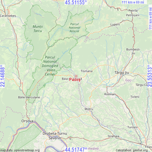
Padeş GPS coordinates[2]
45° 1' 0.012" North, 22° 51' 0" East
| Map corner | latitude | longitude |
|---|---|---|
| Upper-left | 45.51155°, | 22.14688° |
| Center: | 45.01667°, | 22.85° |
| Lower-right: | 44.51747°, | 23.55313° |
| Map W x H: | 110.5×110.5 km | = 68.7×68.7mi |
| max Lat: | 48.23793° ⇑69.4% North |
| Padeş: | 45.01667° |
| min Lat: | ⇓30.6% South 43.65638° |
| min Long | Padeş | max Long |
| 20.31667° | 22.85° | 29.65403° |
| W 13.4%⇐ | ⇒86.6% E |
Elevation
Elevation of Padeş is 274 m = 899 ft, and this is 19.1 m = 63 ft above average elevation for this country.
| Max E: |
1278 m = 4193 ft | 38% |
| Padeş | 274 m 899 ft | |
| Avg. | 254.9 m = 836 ft | |
Min E: |
-2 m = -7 ft | 62% |
See also: Romania elevation on elevation.city.
Geographical zone
Padeş is located in North temperate zone (between Tropic of Cancer and the Arctic Circle). Distance of this North polar circle is 2395.8 km =1488.7 mi to North.| Distance of | km | miles | from Padeş |
|---|---|---|---|
| North Pole | 5001.7 | 3107.9 | to North |
| Arctic Circle | 2395.8 | 1488.7 | to North |
| Tropic Cancer | 2399.5 | 1491 | to South |
| Equator | 5005.4 | 3110.2 | to South |


Nearby cities:
15 places around Padeş: (largest is in red/bold)
• Baia de Aramă
3.8 km =2.4 mi,  239°
239°
• Celei
6.1 km =3.8 mi,  95°
95°
• Cloșani
6.9 km =4.3 mi,  327°
327°
• Costeni
3.6 km =2.2 mi,  88°
88°
• Călugăreni
4.4 km =2.7 mi, 328°
• Glogova
10.8 km =6.7 mi,  155°
155°
• Godineşti
9.4 km =5.8 mi, 101°
• Gornovița
11.2 km =7 mi,  55°
55°
• Motru Sec
6.8 km =4.2 mi,  318°
318°
• Mărășești
6 km =3.7 mi,  274°
274°
• Negoești
3.8 km =2.4 mi,  167°
167°
• Pocruia
6.7 km =4.2 mi, 62°
• Ponoarele
8.2 km =5.1 mi,  234°
234°
• Sohodol
5 km =3.1 mi,  30°
30°
• Tismana
9.9 km =6.2 mi,  67°
67°
Sources, notices
• [Note1] Compared only with cities in Romania existing in our database
• [Src1] Map data: © OpenStreetMap contributors (CC-BY-SA)
• [Src2] Other city data from geonames.org with taken over terms of usage.
• [Src3] Geographical zone / Annual Mean Temperature by Robert A. Rohde @ Wikipedia
