Călugăreni geodata
Călugăreni (Gorj) is a populated place; located in Romania in Europe/Bucharest (GMT+3) time zone. With population of 803 people, there are 5029 cities with bigger population in this country. Compared to other cities in Romania, 67.5% of cities are located further ↑North; 86.8% of cities are located further →East and 72.2% of cities have lower elevation than Călugăreni. Note1


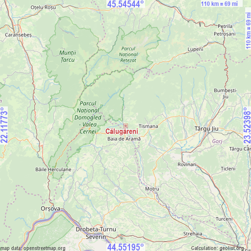
Călugăreni GPS coordinates[2]
45° 3' 3.06" North, 22° 49' 15.06" East
| Map corner | latitude | longitude |
|---|---|---|
| Upper-left | 45.54544°, | 22.11773° |
| Center: | 45.05085°, | 22.82085° |
| Lower-right: | 44.55195°, | 23.52398° |
| Map W x H: | 110.5×110.5 km | = 68.7×68.7mi |
| max Lat: | 48.23793° ⇑67.5% North |
| Călugăreni: | 45.05085° |
| min Lat: | ⇓32.5% South 43.65638° |
| min Long | Călugăreni | max Long |
| 20.31667° | 22.82085° | 29.65403° |
| W 13.2%⇐ | ⇒86.8% E |
Elevation
Elevation of Călugăreni is 335 m = 1099 ft, and this is 80.1 m = 263 ft above average elevation for this country.
| Max E: |
1278 m = 4193 ft | 27.8% |
| Călugăreni | 335 m 1099 ft | |
| Avg. | 254.9 m = 836 ft | |
Min E: |
-2 m = -7 ft | 72.2% |
See also: Romania elevation on elevation.city.
Geographical zone
Călugăreni is located in North temperate zone (between Tropic of Cancer and the Arctic Circle). Distance of this North polar circle is 2392 km =1486.3 mi to North.| Distance of | km | miles | from Călugăreni |
|---|---|---|---|
| North Pole | 4997.9 | 3105.6 | to North |
| Arctic Circle | 2392 | 1486.3 | to North |
| Tropic Cancer | 2403.3 | 1493.3 | to South |
| Equator | 5009.2 | 3112.6 | to South |


Nearby cities:
15 places around Călugăreni: (largest is in red/bold)
• Baia de Aramă
5.8 km =3.6 mi,  190°
190°
• Celei
9.4 km =5.8 mi,  117°
117°
• Cloșani
2.5 km =1.6 mi,  324°
324°
• Costeni
6.9 km =4.3 mi, 122°
• Godineşti
12.8 km =8 mi, 116°
• Gornovița
11.8 km =7.3 mi,  78°
78°
• Motru Sec
2.6 km =1.6 mi,  300°
300°
• Mărășești
4.9 km =3 mi,  227°
227°
• Negoești
8.2 km =5.1 mi,  157°
157°
• Obârşia-Cloşani
11.5 km =7.1 mi,  250°
250°
• Padeş
4.4 km =2.7 mi,  148°
148°
• Pocruia
8.2 km =5.1 mi,  94°
94°
• Ponoarele
9.6 km =6 mi,  207°
207°
• Sohodol
4.8 km =3 mi, 84°
• Tismana
11.5 km =7.1 mi, 90°
Sources, notices
• [Note1] Compared only with cities in Romania existing in our database
• [Src1] Map data: © OpenStreetMap contributors (CC-BY-SA)
• [Src2] Other city data from geonames.org with taken over terms of usage.
• [Src3] Geographical zone / Annual Mean Temperature by Robert A. Rohde @ Wikipedia
