Oţeleni geodata
Oţeleni (Iaşi) is a seat of a second-order administrative division; located in Romania in Europe/Bucharest (GMT+3) time zone. With population of 3,841 people, there are 1234 cities with bigger population in this country. Compared to other cities in Romania, 81% of cities are located further ↓South; 83.5% of cities are located further ←West and 59.2% of cities have lower elevation than Oţeleni. Note1


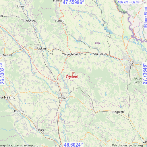
Oţeleni GPS coordinates[2]
47° 4' 59.988" North, 27° 1' 59.988" East
| Map corner | latitude | longitude |
|---|---|---|
| Upper-left | 47.55996°, | 26.33021° |
| Center: | 47.08333°, | 27.03333° |
| Lower-right: | 46.6024°, | 27.73646° |
| Map W x H: | 106.5×106.5 km | = 66.2×66.2mi |
| max Lat: | 48.23793° ⇑19% North |
| Oţeleni: | 47.08333° |
| min Lat: | ⇓81% South 43.65638° |
| min Long | Oţeleni | max Long |
| 20.31667° | 27.03333° | 29.65403° |
| W 83.5%⇐ | ⇒16.5% E |
Elevation
Elevation of Oţeleni is 259 m = 850 ft, and this is 4.1 m = 13 ft above average elevation for this country.
| Max E: |
1278 m = 4193 ft | 40.8% |
| Oţeleni | 259 m 850 ft | |
| Avg. | 254.9 m = 836 ft | |
Min E: |
-2 m = -7 ft | 59.2% |
See also: Romania elevation on elevation.city.
Geographical zone
Oţeleni is located in North temperate zone (between Tropic of Cancer and the Arctic Circle). Distance of this North polar circle is 2166 km =1345.9 mi to North.| Distance of | km | miles | from Oţeleni |
|---|---|---|---|
| North Pole | 4771.9 | 2965.1 | to North |
| Arctic Circle | 2166 | 1345.9 | to North |
| Tropic Cancer | 2629.3 | 1633.8 | to South |
| Equator | 5235.2 | 3253 | to South |


Nearby cities:
15 places around Oţeleni: (largest is in red/bold)
• Boghicea
4.2 km =2.6 mi,  139°
139°
• Brăeşti
9 km =5.6 mi,  34°
34°
• Brătulești
6.7 km =4.2 mi,  314°
314°
• Buhonca
5.3 km =3.3 mi,  220°
220°
• Butea
9 km =5.6 mi,  258°
258°
• Bâra
5.7 km =3.5 mi,  167°
167°
• Cristești
9.5 km =5.9 mi,  22°
22°
• Doljeşti
6.7 km =4.2 mi,  214°
214°
• Gănești
9.3 km =5.8 mi,  359°
359°
• Miclăușeni
7.8 km =4.8 mi,  281°
281°
• Rediu
8.4 km =5.2 mi,  194°
194°
• Rotunda
8.7 km =5.4 mi, 218°
• Răchiteni
9.4 km =5.8 mi,  249°
249°
• Slobozia
6.5 km =4 mi,  109°
109°
• Stăniţa
9 km =5.6 mi,  145°
145°
Sources, notices
• [Note1] Compared only with cities in Romania existing in our database
• [Src1] Map data: © OpenStreetMap contributors (CC-BY-SA)
• [Src2] Other city data from geonames.org with taken over terms of usage.
• [Src3] Geographical zone / Annual Mean Temperature by Robert A. Rohde @ Wikipedia
