Brătulești geodata
Brătulești (Iaşi) is a populated place; located in Romania in Europe/Bucharest (GMT+3) time zone. With population of 533 people, there are 6748 cities with bigger population in this country. Compared to other cities in Romania, 82% of cities are located further ↓South; 82.4% of cities are located further ←West and 54.8% of cities have lower elevation than Brătulești. Note1


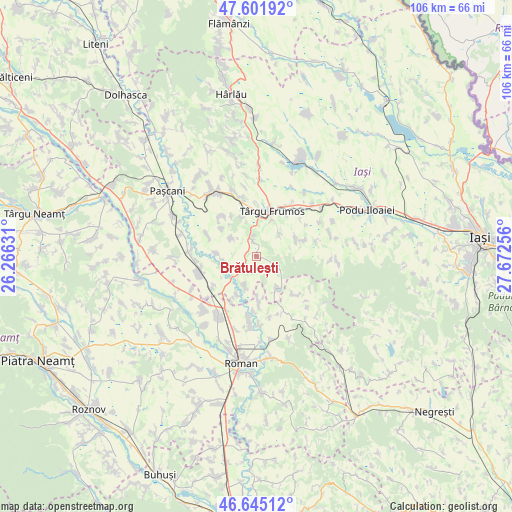
Brătulești GPS coordinates[2]
47° 7' 32.412" North, 26° 58' 9.948" East
| Map corner | latitude | longitude |
|---|---|---|
| Upper-left | 47.60192°, | 26.26631° |
| Center: | 47.12567°, | 26.96943° |
| Lower-right: | 46.64512°, | 27.67256° |
| Map W x H: | 106.4×106.4 km | = 66.1×66.1mi |
| max Lat: | 48.23793° ⇑18% North |
| Brătulești: | 47.12567° |
| min Lat: | ⇓82% South 43.65638° |
| min Long | Brătulești | max Long |
| 20.31667° | 26.96943° | 29.65403° |
| W 82.4%⇐ | ⇒17.6% E |
Elevation
Elevation of Brătulești is 237 m = 778 ft, and this is 17.9 m = 59 ft below average elevation for this country.
| Max E: |
1278 m = 4193 ft | 45.2% |
| Avg. | 254.9 m = 836 ft | |
| Brătulești | 237 m = 778 ft | |
Min E: |
-2 m = -7 ft | 54.8% |
See also: Romania elevation on elevation.city.
Geographical zone
Brătulești is located in North temperate zone (between Tropic of Cancer and the Arctic Circle). Distance of this North polar circle is 2161.3 km =1343 mi to North.| Distance of | km | miles | from Brătulești |
|---|---|---|---|
| North Pole | 4767.2 | 2962.2 | to North |
| Arctic Circle | 2161.3 | 1343 | to North |
| Tropic Cancer | 2634 | 1636.7 | to South |
| Equator | 5239.9 | 3255.9 | to South |


Nearby cities:
15 places around Brătulești: (largest is in red/bold)
• Alexandru I. Cuza
9.1 km =5.7 mi,  275°
275°
• Brăeşti
10.2 km =6.3 mi,  74°
74°
• Buhonca
8.8 km =5.5 mi,  170°
170°
• Butea
7.7 km =4.8 mi,  211°
211°
• Buznea
8.5 km =5.3 mi,  24°
24°
• Cristești
9.4 km =5.8 mi,  64°
64°
• Fărcășeni
6.7 km =4.2 mi,  304°
304°
• Gănești
6.6 km =4.1 mi,  45°
45°
• Miclăușeni
4.2 km =2.6 mi,  221°
221°
• Oboroceni
9 km =5.6 mi,  309°
309°
• Oţeleni
6.7 km =4.2 mi,  134°
134°
• Răchiteni
8.9 km =5.5 mi, 206°
• Scheia
6.7 km =4.2 mi,  261°
261°
• Strunga
4.7 km =2.9 mi,  12°
12°
• Târgu Frumos
8.6 km =5.3 mi, 15°
Sources, notices
• [Note1] Compared only with cities in Romania existing in our database
• [Src1] Map data: © OpenStreetMap contributors (CC-BY-SA)
• [Src2] Other city data from geonames.org with taken over terms of usage.
• [Src3] Geographical zone / Annual Mean Temperature by Robert A. Rohde @ Wikipedia
