Oleșești geodata
Oleșești (Vrancea) is a populated place; located in Romania in Europe/Bucharest (GMT+3) time zone. With population of 1,001 people, there are 4289 cities with bigger population in this country. Compared to other cities in Romania, 51.4% of cities are located further ↓South; 85.3% of cities are located further ←West and 64.7% of cities have higher elevation than Oleșești. Note1


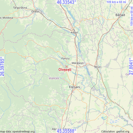
Oleșești GPS coordinates[2]
45° 50' 52.116" North, 27° 6' 3.492" East
| Map corner | latitude | longitude |
|---|---|---|
| Upper-left | 46.33543°, | 26.39785° |
| Center: | 45.84781°, | 27.10097° |
| Lower-right: | 45.35588°, | 27.8041° |
| Map W x H: | 108.9×108.9 km | = 67.7×67.7mi |
| max Lat: | 48.23793° ⇑48.6% North |
| Oleșești: | 45.84781° |
| min Lat: | ⇓51.4% South 43.65638° |
| min Long | Oleșești | max Long |
| 20.31667° | 27.10097° | 29.65403° |
| W 85.3%⇐ | ⇒14.7% E |
Elevation
Elevation of Oleșești is 148 m = 486 ft, and this is 106.9 m = 351 ft below average elevation for this country.
| Max E: |
1278 m = 4193 ft | 64.7% |
| Avg. | 254.9 m = 836 ft | |
| Oleșești | 148 m = 486 ft | |
Min E: |
-2 m = -7 ft | 35.3% |
See also: Romania elevation on elevation.city.
Geographical zone
Oleșești is located in North temperate zone (between Tropic of Cancer and the Arctic Circle). Distance of this North polar circle is 2303.4 km =1431.3 mi to North.| Distance of | km | miles | from Oleșești |
|---|---|---|---|
| North Pole | 4909.3 | 3050.5 | to North |
| Arctic Circle | 2303.4 | 1431.3 | to North |
| Tropic Cancer | 2491.9 | 1548.4 | to South |
| Equator | 5097.8 | 3167.6 | to South |


Nearby cities:
15 places around Oleșești: (largest is in red/bold)
• Boloteşti
3.1 km =1.9 mi,  238°
238°
• Dumbrava
6.9 km =4.3 mi,  7°
7°
• Găgești
3.6 km =2.2 mi,  284°
284°
• Igești
7 km =4.3 mi,  115°
115°
• Jariştea
7.6 km =4.7 mi,  200°
200°
• Panciu
6 km =3.7 mi,  346°
346°
• Pietroasa
5 km =3.1 mi,  292°
292°
• Putna
2.4 km =1.5 mi,  183°
183°
• Pădureni
7.9 km =4.9 mi,  219°
219°
• Satu Nou
4.6 km =2.9 mi,  357°
357°
• Sârbi
3.7 km =2.3 mi,  311°
311°
• Vitănești
6.2 km =3.9 mi, 309°
• Vităneștii de Sub Măgură
6.4 km =4 mi,  297°
297°
• Vărsătura
7.9 km =4.9 mi,  213°
213°
• Ţifeşti
0.3 km =0.2 mi,  342°
342°
Sources, notices
• [Note1] Compared only with cities in Romania existing in our database
• [Src1] Map data: © OpenStreetMap contributors (CC-BY-SA)
• [Src2] Other city data from geonames.org with taken over terms of usage.
• [Src3] Geographical zone / Annual Mean Temperature by Robert A. Rohde @ Wikipedia
