Negreia geodata
Negreia (Maramureş) is a populated place; located in Romania in Europe/Bucharest (GMT+3) time zone. With population of 565 people, there are 6466 cities with bigger population in this country. Compared to other cities in Romania, 93.8% of cities are located further ↓South; 73.5% of cities are located further →East and 91.4% of cities have lower elevation than Negreia. Note1


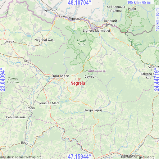
Negreia GPS coordinates[2]
47° 38' 7.404" North, 23° 44' 38.616" East
| Map corner | latitude | longitude |
|---|---|---|
| Upper-left | 48.10704°, | 23.04094° |
| Center: | 47.63539°, | 23.74406° |
| Lower-right: | 47.15944°, | 24.44719° |
| Map W x H: | 105.4×105.4 km | = 65.5×65.5mi |
| max Lat: | 48.23793° ⇑6.2% North |
| Negreia: | 47.63539° |
| min Lat: | ⇓93.8% South 43.65638° |
| min Long | Negreia | max Long |
| 20.31667° | 23.74406° | 29.65403° |
| W 26.5%⇐ | ⇒73.5% E |
Elevation
Elevation of Negreia is 536 m = 1759 ft, and this is 281.1 m = 922 ft above average elevation for this country.
| Max E: |
1278 m = 4193 ft | 8.6% |
| Negreia | 536 m 1759 ft | |
| Avg. | 254.9 m = 836 ft | |
Min E: |
-2 m = -7 ft | 91.4% |
See also: Romania elevation on elevation.city.
Geographical zone
Negreia is located in North temperate zone (between Tropic of Cancer and the Arctic Circle). Distance of this North polar circle is 2104.6 km =1307.7 mi to North.| Distance of | km | miles | from Negreia |
|---|---|---|---|
| North Pole | 4710.5 | 2927 | to North |
| Arctic Circle | 2104.6 | 1307.7 | to North |
| Tropic Cancer | 2690.6 | 1671.9 | to South |
| Equator | 5296.6 | 3291.2 | to South |


Nearby cities:
15 places around Negreia: (largest is in red/bold)
• Baia Sprie
4.9 km =3 mi,  307°
307°
• Cavnic
9.8 km =6.1 mi,  69°
69°
• Cetățele
4.1 km =2.5 mi,  184°
184°
• Chiuzbaia
8.6 km =5.3 mi,  326°
326°
• Ciocotiș
9.6 km =6 mi,  155°
155°
• Dumbrăviţa
8.1 km =5 mi,  240°
240°
• Dănești
1.9 km =1.2 mi,  206°
206°
• Făurești
8 km =5 mi, 176°
• Plopiș
5.5 km =3.4 mi, 157°
• Rus
6.1 km =3.8 mi,  245°
245°
• Trestia
8.7 km =5.4 mi,  154°
154°
• Tăuții de Sus
6.8 km =4.2 mi,  290°
290°
• Șindrești
4.9 km =3 mi,  228°
228°
• Șisești
2.7 km =1.7 mi,  269°
269°
• Șurdești
4.1 km =2.5 mi, 153°
Sources, notices
• [Note1] Compared only with cities in Romania existing in our database
• [Src1] Map data: © OpenStreetMap contributors (CC-BY-SA)
• [Src2] Other city data from geonames.org with taken over terms of usage.
• [Src3] Geographical zone / Annual Mean Temperature by Robert A. Rohde @ Wikipedia
