Nămoloasa-Sat geodata
Nămoloasa-Sat (Galaţi) is a populated place; located in Romania in Europe/Bucharest (GMT+3) time zone. With population of 2,373 people, there are 2257 cities with bigger population in this country. Compared to other cities in Romania, 54.6% of cities are located further ↑North; 92% of cities are located further ←West and 99.2% of cities have higher elevation than Nămoloasa-Sat. Note1


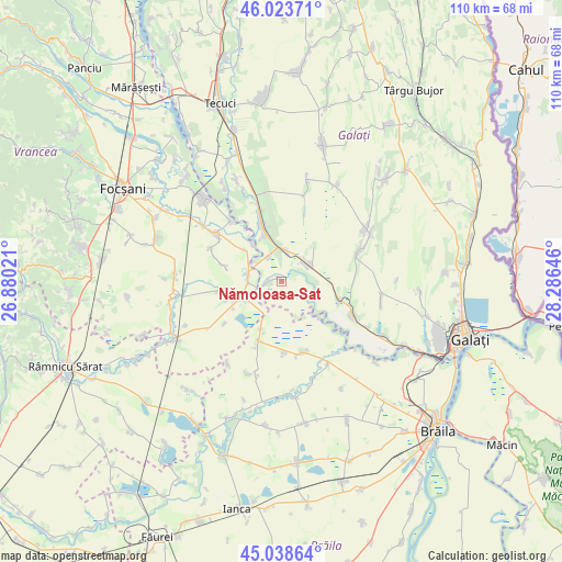
Nămoloasa-Sat GPS coordinates[2]
45° 31' 59.988" North, 27° 34' 59.988" East
| Map corner | latitude | longitude |
|---|---|---|
| Upper-left | 46.02371°, | 26.88021° |
| Center: | 45.53333°, | 27.58333° |
| Lower-right: | 45.03864°, | 28.28646° |
| Map W x H: | 109.5×109.5 km | = 68×68mi |
| max Lat: | 48.23793° ⇑54.6% North |
| Nămoloasa-Sat: | 45.53333° |
| min Lat: | ⇓45.4% South 43.65638° |
| min Long | Nămoloasa-Sat | max Long |
| 20.31667° | 27.58333° | 29.65403° |
| W 92%⇐ | ⇒8% E |
Elevation
Elevation of Nămoloasa-Sat is 10 m = 33 ft, and this is 244.9 m = 803 ft below average elevation for this country.
| Max E: |
1278 m = 4193 ft | 99.2% |
| Avg. | 254.9 m = 836 ft | |
| Nămoloasa-Sat | 10 m = 33 ft | |
Min E: |
-2 m = -7 ft | 0.8% |
See also: Romania elevation on elevation.city.
Geographical zone
Nămoloasa-Sat is located in North temperate zone (between Tropic of Cancer and the Arctic Circle). Distance of this North polar circle is 2338.3 km =1453 mi to North.| Distance of | km | miles | from Nămoloasa-Sat |
|---|---|---|---|
| North Pole | 4944.2 | 3072.2 | to North |
| Arctic Circle | 2338.3 | 1453 | to North |
| Tropic Cancer | 2456.9 | 1526.6 | to South |
| Equator | 5062.8 | 3145.9 | to South |


Nearby cities:
15 places around Nămoloasa-Sat: (largest is in red/bold)
• Călienii Noi
9.6 km =6 mi,  311°
311°
• Călienii Vechi
9.4 km =5.8 mi,  322°
322°
• Fundeni
3.4 km =2.1 mi,  284°
284°
• Fundenii Noi
5.4 km =3.4 mi,  330°
330°
• Hanu Conachi
6 km =3.7 mi,  8°
8°
• Lieşti
10.6 km =6.6 mi, 330°
• Lungoci
6.2 km =3.9 mi, 306°
• Maluri
11.6 km =7.2 mi,  285°
285°
• Măicăneşti
7.5 km =4.7 mi,  240°
240°
• Nămoloasa
2.4 km =1.5 mi, 277°
• Năneşti
6.7 km =4.2 mi, 285°
• Piscu
12.3 km =7.6 mi,  107°
107°
• Râmniceni
10.7 km =6.6 mi,  257°
257°
• Tudor Vladimirescu
6.4 km =4 mi,  54°
54°
• Tătaru
9.3 km =5.8 mi,  247°
247°
Sources, notices
• [Note1] Compared only with cities in Romania existing in our database
• [Src1] Map data: © OpenStreetMap contributors (CC-BY-SA)
• [Src2] Other city data from geonames.org with taken over terms of usage.
• [Src3] Geographical zone / Annual Mean Temperature by Robert A. Rohde @ Wikipedia
