Nămoloasa geodata
Nămoloasa (Galaţi) is a seat of a second-order administrative division; located in Romania in Europe/Bucharest (GMT+3) time zone. With population of 1,226 people, there are 3688 cities with bigger population in this country. Compared to other cities in Romania, 54.5% of cities are located further ↑North; 91.7% of cities are located further ←West and 98.6% of cities have higher elevation than Nămoloasa. Note1


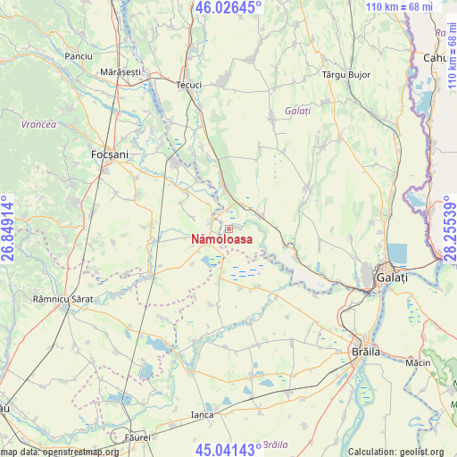
Nămoloasa GPS coordinates[2]
45° 32' 9.96" North, 27° 33' 8.136" East
| Map corner | latitude | longitude |
|---|---|---|
| Upper-left | 46.02645°, | 26.84914° |
| Center: | 45.5361°, | 27.55226° |
| Lower-right: | 45.04143°, | 28.25539° |
| Map W x H: | 109.5×109.5 km | = 68×68mi |
| max Lat: | 48.23793° ⇑54.5% North |
| Nămoloasa: | 45.5361° |
| min Lat: | ⇓45.5% South 43.65638° |
| min Long | Nămoloasa | max Long |
| 20.31667° | 27.55226° | 29.65403° |
| W 91.7%⇐ | ⇒8.3% E |
Elevation
Elevation of Nămoloasa is 14 m = 46 ft, and this is 240.9 m = 790 ft below average elevation for this country.
| Max E: |
1278 m = 4193 ft | 98.6% |
| Avg. | 254.9 m = 836 ft | |
| Nămoloasa | 14 m = 46 ft | |
Min E: |
-2 m = -7 ft | 1.4% |
See also: Romania elevation on elevation.city.
Geographical zone
Nămoloasa is located in North temperate zone (between Tropic of Cancer and the Arctic Circle). Distance of this North polar circle is 2338 km =1452.8 mi to North.| Distance of | km | miles | from Nămoloasa |
|---|---|---|---|
| North Pole | 4943.9 | 3072 | to North |
| Arctic Circle | 2338 | 1452.8 | to North |
| Tropic Cancer | 2457.2 | 1526.8 | to South |
| Equator | 5063.1 | 3146.1 | to South |


Nearby cities:
15 places around Nămoloasa: (largest is in red/bold)
• Călienii Noi
7.7 km =4.8 mi,  321°
321°
• Călienii Vechi
7.8 km =4.8 mi,  334°
334°
• Fundeni
1.1 km =0.7 mi,  302°
302°
• Fundenii Noi
4.4 km =2.7 mi,  357°
357°
• Hanu Conachi
6.5 km =4 mi,  30°
30°
• Lieşti
9.4 km =5.8 mi,  342°
342°
• Lungoci
4.2 km =2.6 mi, 322°
• Maluri
9.2 km =5.7 mi,  287°
287°
• Măicăneşti
5.7 km =3.5 mi,  225°
225°
• Nămoloasa-Sat
2.4 km =1.5 mi,  97°
97°
• Năneşti
4.4 km =2.7 mi, 290°
• Râmniceni
8.5 km =5.3 mi,  252°
252°
• Slobozia Botești
10.1 km =6.3 mi,  258°
258°
• Tudor Vladimirescu
8.3 km =5.2 mi,  65°
65°
• Tătaru
7.3 km =4.5 mi,  238°
238°
Sources, notices
• [Note1] Compared only with cities in Romania existing in our database
• [Src1] Map data: © OpenStreetMap contributors (CC-BY-SA)
• [Src2] Other city data from geonames.org with taken over terms of usage.
• [Src3] Geographical zone / Annual Mean Temperature by Robert A. Rohde @ Wikipedia
