Nădrag geodata
Nădrag (Timiş) is a seat of a second-order administrative division; located in Romania in Europe/Bucharest (GMT+3) time zone. With population of 2,897 people, there are 1849 cities with bigger population in this country. Compared to other cities in Romania, 52.8% of cities are located further ↑North; 92.9% of cities are located further →East and 62.7% of cities have lower elevation than Nădrag. Note1


Nădrag GPS coordinates[2]
45° 39' 0" North, 22° 10' 59.988" East
| Map corner | latitude | longitude |
|---|---|---|
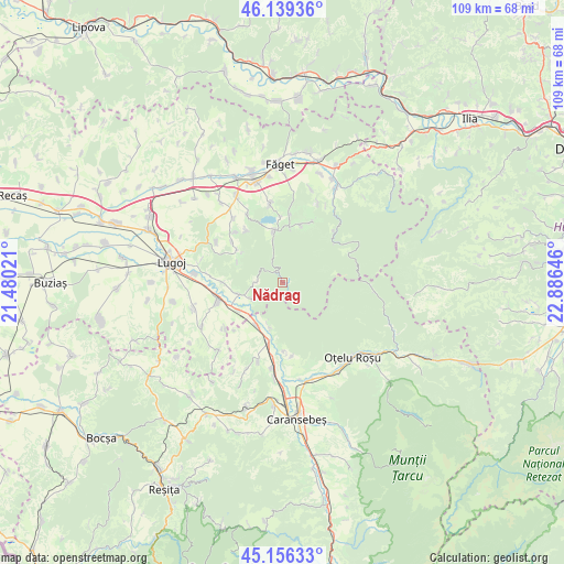
| Upper-left | 46.13936°, | 21.48021° |
| Center: | 45.65°, | 22.18333° |
| Lower-right: | 45.15633°, | 22.88646° |
| Map W x H: | 109.3×109.3 km | = 67.9×67.9mi |
| max Lat: | 48.23793° ⇑52.8% North |
| Nădrag: | 45.65° |
| min Lat: | ⇓47.2% South 43.65638° |
| min Long | Nădrag | max Long |
| 20.31667° | 22.18333° | 29.65403° |
| W 7.1%⇐ | ⇒92.9% E |
Elevation
Elevation of Nădrag is 278 m = 912 ft, and this is 23.1 m = 76 ft above average elevation for this country.
| Max E: |
1278 m = 4193 ft | 37.3% |
| Nădrag | 278 m 912 ft | |
| Avg. | 254.9 m = 836 ft | |
Min E: |
-2 m = -7 ft | 62.7% |
See also: Romania elevation on elevation.city.
Geographical zone
Nădrag is located in North temperate zone (between Tropic of Cancer and the Arctic Circle). Distance of this North polar circle is 2325.4 km =1444.9 mi to North.| Distance of | km | miles | from Nădrag |
|---|---|---|---|
| North Pole | 4931.3 | 3064.2 | to North |
| Arctic Circle | 2325.4 | 1444.9 | to North |
| Tropic Cancer | 2469.9 | 1534.7 | to South |
| Equator | 5075.8 | 3154 | to South |


Nearby cities:
15 places around Nădrag: (largest is in red/bold)
• Bucovăț
15.8 km =9.8 mi,  351°
351°
• Bârna
12.7 km =7.9 mi,  305°
305°
• Colonia Fabricii
16.5 km =10.3 mi,  38°
38°
• Constantin Daicoviciu
11.4 km =7.1 mi,  193°
193°
• Copăcele
17.9 km =11.1 mi,  201°
201°
• Criciova
9.3 km =5.8 mi,  258°
258°
• Fârdea
9.4 km =5.8 mi, 352°
• Gavojdia
13.5 km =8.4 mi,  254°
254°
• Jdioara
6.8 km =4.2 mi,  241°
241°
• Jena
9.9 km =6.2 mi, 237°
• Lugojel
17.3 km =10.7 mi,  276°
276°
• Măguri
14.3 km =8.9 mi, 275°
• Rușchița
18.1 km =11.2 mi,  95°
95°
• Sacu
10.6 km =6.6 mi,  209°
209°
• Tomeşti
17.4 km =10.8 mi,  31°
31°
Sources, notices
• [Note1] Compared only with cities in Romania existing in our database
• [Src1] Map data: © OpenStreetMap contributors (CC-BY-SA)
• [Src2] Other city data from geonames.org with taken over terms of usage.
• [Src3] Geographical zone / Annual Mean Temperature by Robert A. Rohde @ Wikipedia
