Moşoaia geodata
Moşoaia (Arges) is a seat of a second-order administrative division; located in Romania in Europe/Bucharest (GMT+3) time zone. With population of 4,267 people, there are 1065 cities with bigger population in this country. Compared to other cities in Romania, 76.2% of cities are located further ↑North; 56.1% of cities are located further →East and 76.7% of cities have lower elevation than Moşoaia. Note1


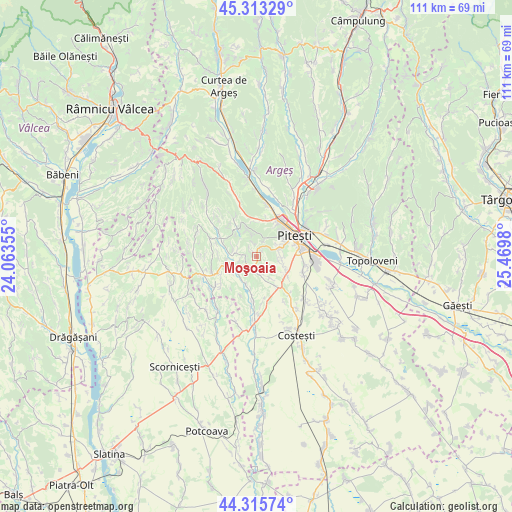
Moşoaia GPS coordinates[2]
44° 49' 0.012" North, 24° 46' 0.012" East
| Map corner | latitude | longitude |
|---|---|---|
| Upper-left | 45.31329°, | 24.06355° |
| Center: | 44.81667°, | 24.76667° |
| Lower-right: | 44.31574°, | 25.4698° |
| Map W x H: | 110.9×110.9 km | = 68.9×68.9mi |
| max Lat: | 48.23793° ⇑76.2% North |
| Moşoaia: | 44.81667° |
| min Lat: | ⇓23.8% South 43.65638° |
| min Long | Moşoaia | max Long |
| 20.31667° | 24.76667° | 29.65403° |
| W 43.9%⇐ | ⇒56.1% E |
Elevation
Elevation of Moşoaia is 366 m = 1201 ft, and this is 111.1 m = 365 ft above average elevation for this country.
| Max E: |
1278 m = 4193 ft | 23.3% |
| Moşoaia | 366 m 1201 ft | |
| Avg. | 254.9 m = 836 ft | |
Min E: |
-2 m = -7 ft | 76.7% |
See also: Romania elevation on elevation.city.
Geographical zone
Moşoaia is located in North temperate zone (between Tropic of Cancer and the Arctic Circle). Distance of this Northern Tropic circle is 2377.2 km =1477.1 mi to South.| Distance of | km | miles | from Moşoaia |
|---|---|---|---|
| North Pole | 5023.9 | 3121.7 | to North |
| Arctic Circle | 2418 | 1502.5 | to North |
| Tropic Cancer | 2377.2 | 1477.1 | to South |
| Equator | 4983.1 | 3096.4 | to South |


Nearby cities:
15 places around Moşoaia: (largest is in red/bold)
• Albota
7.5 km =4.7 mi,  119°
119°
• Albota de Jos
7.7 km =4.8 mi,  136°
136°
• Cerbu
7.8 km =4.8 mi,  146°
146°
• Ciobănești
6 km =3.7 mi,  340°
340°
• Ciocănăi
3.5 km =2.2 mi,  25°
25°
• Hințești
6.2 km =3.9 mi,  93°
93°
• Mareș
4.7 km =2.9 mi,  156°
156°
• Mica
7.6 km =4.7 mi,  354°
354°
• Poiana Lacului
2.6 km =1.6 mi,  270°
270°
• Păduroiu din Deal
4.4 km =2.7 mi,  234°
234°
• Păduroiu din Vale
6.5 km =4 mi, 234°
• Smeura
5.8 km =3.6 mi,  70°
70°
• Sămara
4.3 km =2.7 mi,  283°
283°
• Uiasca
8.7 km =5.4 mi, 31°
• Valea Ursului
8.1 km =5 mi,  2°
2°
Sources, notices
• [Note1] Compared only with cities in Romania existing in our database
• [Src1] Map data: © OpenStreetMap contributors (CC-BY-SA)
• [Src2] Other city data from geonames.org with taken over terms of usage.
• [Src3] Geographical zone / Annual Mean Temperature by Robert A. Rohde @ Wikipedia
