Ciobănești geodata
Ciobănești (Arges) is a populated place; located in Romania in Europe/Bucharest (GMT+3) time zone. With population of 622 people, there are 6068 cities with bigger population in this country. Compared to other cities in Romania, 74.1% of cities are located further ↑North; 56.5% of cities are located further →East and 82.8% of cities have lower elevation than Ciobănești. Note1


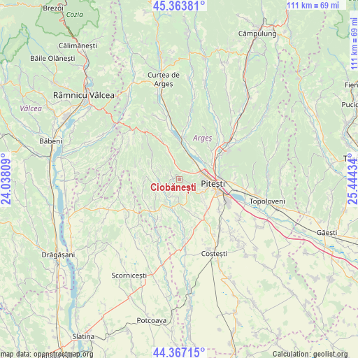
Ciobănești GPS coordinates[2]
44° 52' 3.504" North, 24° 44' 28.356" East
| Map corner | latitude | longitude |
|---|---|---|
| Upper-left | 45.36381°, | 24.03809° |
| Center: | 44.86764°, | 24.74121° |
| Lower-right: | 44.36715°, | 25.44434° |
| Map W x H: | 110.8×110.8 km | = 68.8×68.8mi |
| max Lat: | 48.23793° ⇑74.1% North |
| Ciobănești: | 44.86764° |
| min Lat: | ⇓25.9% South 43.65638° |
| min Long | Ciobănești | max Long |
| 20.31667° | 24.74121° | 29.65403° |
| W 43.5%⇐ | ⇒56.5% E |
Elevation
Elevation of Ciobănești is 421 m = 1381 ft, and this is 166.1 m = 545 ft above average elevation for this country.
| Max E: |
1278 m = 4193 ft | 17.2% |
| Ciobănești | 421 m 1381 ft | |
| Avg. | 254.9 m = 836 ft | |
Min E: |
-2 m = -7 ft | 82.8% |
See also: Romania elevation on elevation.city.
Geographical zone
Ciobănești is located in North temperate zone (between Tropic of Cancer and the Arctic Circle). Distance of this Northern Tropic circle is 2382.9 km =1480.7 mi to South.| Distance of | km | miles | from Ciobănești |
|---|---|---|---|
| North Pole | 5018.2 | 3118.2 | to North |
| Arctic Circle | 2412.4 | 1499 | to North |
| Tropic Cancer | 2382.9 | 1480.7 | to South |
| Equator | 4988.8 | 3099.9 | to South |


Nearby cities:
15 places around Ciobănești: (largest is in red/bold)
• Başcov
6.9 km =4.3 mi,  58°
58°
• Băbana
4.8 km =3 mi,  317°
317°
• Ciocănăi
4.3 km =2.7 mi,  124°
124°
• Cocu
7.2 km =4.5 mi,  269°
269°
• Dobrogostea
7.6 km =4.7 mi,  25°
25°
• Drăganu-Olteni
7.6 km =4.7 mi,  345°
345°
• Glâmbocu
5 km =3.1 mi,  54°
54°
• Mica
2.3 km =1.4 mi, 34°
• Moşoaia
6 km =3.7 mi,  160°
160°
• Poiana Lacului
5.7 km =3.5 mi,  186°
186°
• Prislopu Mare
4 km =2.5 mi, 351°
• Răchițele de Jos
6.4 km =4 mi,  288°
288°
• Sămara
5.1 km =3.2 mi,  204°
204°
• Uiasca
6.7 km =4.2 mi,  74°
74°
• Valea Ursului
3.4 km =2.1 mi,  44°
44°
Sources, notices
• [Note1] Compared only with cities in Romania existing in our database
• [Src1] Map data: © OpenStreetMap contributors (CC-BY-SA)
• [Src2] Other city data from geonames.org with taken over terms of usage.
• [Src3] Geographical zone / Annual Mean Temperature by Robert A. Rohde @ Wikipedia
