Mișca geodata
Mișca (Arad) is a seat of a second-order administrative division; located in Romania in Europe/Bucharest (GMT+3) time zone. With population of 1,165 people, there are 3811 cities with bigger population in this country. Compared to other cities in Romania, 69.5% of cities are located further ↓South; 97.1% of cities are located further →East and 80.8% of cities have higher elevation than Mișca. Note1


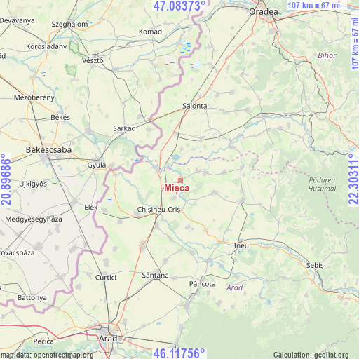
Mișca GPS coordinates[2]
46° 36' 10.08" North, 21° 35' 59.928" East
| Map corner | latitude | longitude |
|---|---|---|
| Upper-left | 47.08373°, | 20.89686° |
| Center: | 46.6028°, | 21.59998° |
| Lower-right: | 46.11756°, | 22.30311° |
| Map W x H: | 107.4×107.4 km | = 66.7×66.7mi |
| max Lat: | 48.23793° ⇑30.5% North |
| Mișca: | 46.6028° |
| min Lat: | ⇓69.5% South 43.65638° |
| min Long | Mișca | max Long |
| 20.31667° | 21.59998° | 29.65403° |
| W 2.9%⇐ | ⇒97.1% E |
Elevation
Elevation of Mișca is 92 m = 302 ft, and this is 162.9 m = 534 ft below average elevation for this country.
| Max E: |
1278 m = 4193 ft | 80.8% |
| Avg. | 254.9 m = 836 ft | |
| Mișca | 92 m = 302 ft | |
Min E: |
-2 m = -7 ft | 19.2% |
See also: Romania elevation on elevation.city.
Geographical zone
Mișca is located in North temperate zone (between Tropic of Cancer and the Arctic Circle). Distance of this North polar circle is 2219.4 km =1379.1 mi to North.| Distance of | km | miles | from Mișca |
|---|---|---|---|
| North Pole | 4825.3 | 2998.3 | to North |
| Arctic Circle | 2219.4 | 1379.1 | to North |
| Tropic Cancer | 2575.8 | 1600.5 | to South |
| Equator | 5181.7 | 3219.8 | to South |


Nearby cities:
15 places around Mișca: (largest is in red/bold)
• Adea
5.4 km =3.4 mi,  192°
192°
• Apateu
14.1 km =8.8 mi,  83°
83°
• Avram Iancu
9.4 km =5.8 mi,  322°
322°
• Boiu
9.3 km =5.8 mi,  5°
5°
• Chişineu-Criş
10.7 km =6.6 mi,  215°
215°
• Ciumeghiu
14.6 km =9.1 mi,  354°
354°
• Ghiorac
13.8 km =8.6 mi,  27°
27°
• Iermata Neagră
8.7 km =5.4 mi,  296°
296°
• Satu Nou
8.2 km =5.1 mi,  74°
74°
• Sintea Mare
9.6 km =6 mi,  179°
179°
• Tămașda
5.7 km =3.5 mi, 324°
• Vânători
6.1 km =3.8 mi, 66°
• Zerind
6.5 km =4 mi,  283°
283°
• Șepreuș
10.8 km =6.7 mi,  108°
108°
• Țipar
14.4 km =8.9 mi,  169°
169°
Sources, notices
• [Note1] Compared only with cities in Romania existing in our database
• [Src1] Map data: © OpenStreetMap contributors (CC-BY-SA)
• [Src2] Other city data from geonames.org with taken over terms of usage.
• [Src3] Geographical zone / Annual Mean Temperature by Robert A. Rohde @ Wikipedia
