Ghiorac geodata
Ghiorac (Bihor) is a populated place; located in Romania in Europe/Bucharest (GMT+3) time zone. With population of 1,922 people, there are 2683 cities with bigger population in this country. Compared to other cities in Romania, 72% of cities are located further ↓South; 96.7% of cities are located further →East and 79.6% of cities have higher elevation than Ghiorac. Note1


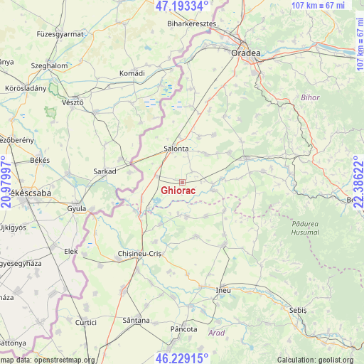
Ghiorac GPS coordinates[2]
46° 42' 48.24" North, 21° 40' 59.124" East
| Map corner | latitude | longitude |
|---|---|---|
| Upper-left | 47.19334°, | 20.97997° |
| Center: | 46.7134°, | 21.68309° |
| Lower-right: | 46.22915°, | 22.38622° |
| Map W x H: | 107.2×107.2 km | = 66.6×66.6mi |
| max Lat: | 48.23793° ⇑28% North |
| Ghiorac: | 46.7134° |
| min Lat: | ⇓72% South 43.65638° |
| min Long | Ghiorac | max Long |
| 20.31667° | 21.68309° | 29.65403° |
| W 3.3%⇐ | ⇒96.7% E |
Elevation
Elevation of Ghiorac is 96 m = 315 ft, and this is 158.9 m = 521 ft below average elevation for this country.
| Max E: |
1278 m = 4193 ft | 79.6% |
| Avg. | 254.9 m = 836 ft | |
| Ghiorac | 96 m = 315 ft | |
Min E: |
-2 m = -7 ft | 20.4% |
See also: Romania elevation on elevation.city.
Geographical zone
Ghiorac is located in North temperate zone (between Tropic of Cancer and the Arctic Circle). Distance of this North polar circle is 2207.1 km =1371.4 mi to North.| Distance of | km | miles | from Ghiorac |
|---|---|---|---|
| North Pole | 4813 | 2990.7 | to North |
| Arctic Circle | 2207.1 | 1371.4 | to North |
| Tropic Cancer | 2588.1 | 1608.2 | to South |
| Equator | 5194 | 3227.4 | to South |


Nearby cities:
15 places around Ghiorac: (largest is in red/bold)
• Apateu
13.2 km =8.2 mi,  144°
144°
• Arpășel
4 km =2.5 mi,  44°
44°
• Avram Iancu
13.1 km =8.1 mi,  248°
248°
• Batăr
10.3 km =6.4 mi,  98°
98°
• Boiu
6.3 km =3.9 mi,  241°
241°
• Ciumeghiu
7.9 km =4.9 mi,  286°
286°
• Căuașd
13.5 km =8.4 mi,  50°
50°
• Mădăraş
13.3 km =8.3 mi,  0°
0°
• Salonta
10 km =6.2 mi,  345°
345°
• Satu Nou
10.2 km =6.3 mi,  171°
171°
• Talpoș
9.5 km =5.9 mi,  105°
105°
• Tulca
10.9 km =6.8 mi, 44°
• Tămașda
12.3 km =7.6 mi,  231°
231°
• Tăut
11.9 km =7.4 mi,  86°
86°
• Vânători
9.9 km =6.2 mi,  184°
184°
Sources, notices
• [Note1] Compared only with cities in Romania existing in our database
• [Src1] Map data: © OpenStreetMap contributors (CC-BY-SA)
• [Src2] Other city data from geonames.org with taken over terms of usage.
• [Src3] Geographical zone / Annual Mean Temperature by Robert A. Rohde @ Wikipedia
