Miorcani geodata
Miorcani (Botoşani) is a populated place; located in Romania in Europe/Bucharest (GMT+3) time zone. With population of 2,248 people, there are 2374 cities with bigger population in this country. Compared to other cities in Romania, 99.9% of cities are located further ↓South; 79.9% of cities are located further ←West and 56.1% of cities have higher elevation than Miorcani. Note1


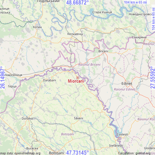
Miorcani GPS coordinates[2]
48° 12' 8.028" North, 26° 51' 10.044" East
| Map corner | latitude | longitude |
|---|---|---|
| Upper-left | 48.66872°, | 26.14967° |
| Center: | 48.20223°, | 26.85279° |
| Lower-right: | 47.73145°, | 27.55592° |
| Map W x H: | 104.2×104.2 km | = 64.7×64.7mi |
| max Lat: | 48.23793° ⇑0.1% North |
| Miorcani: | 48.20223° |
| min Lat: | ⇓99.9% South 43.65638° |
| min Long | Miorcani | max Long |
| 20.31667° | 26.85279° | 29.65403° |
| W 79.9%⇐ | ⇒20.1% E |
Elevation
Elevation of Miorcani is 182 m = 597 ft, and this is 72.9 m = 239 ft below average elevation for this country.
| Max E: |
1278 m = 4193 ft | 56.1% |
| Avg. | 254.9 m = 836 ft | |
| Miorcani | 182 m = 597 ft | |
Min E: |
-2 m = -7 ft | 43.9% |
See also: Romania elevation on elevation.city.
Geographical zone
Miorcani is located in North temperate zone (between Tropic of Cancer and the Arctic Circle). Distance of this North polar circle is 2041.6 km =1268.6 mi to North.| Distance of | km | miles | from Miorcani |
|---|---|---|---|
| North Pole | 4647.5 | 2887.8 | to North |
| Arctic Circle | 2041.6 | 1268.6 | to North |
| Tropic Cancer | 2753.7 | 1711.1 | to South |
| Equator | 5359.6 | 3330.3 | to South |


Nearby cities:
15 places around Miorcani: (largest is in red/bold)
• Codreni
13.1 km =8.1 mi,  202°
202°
• Cotu Miculinți
7.1 km =4.4 mi,  103°
103°
• Coţuşca
7.7 km =4.8 mi,  181°
181°
• Crasnaleuca
9.2 km =5.7 mi,  123°
123°
• Cuza Vodă
11.7 km =7.3 mi,  261°
261°
• Ghireni
6.1 km =3.8 mi,  155°
155°
• Horia
12.7 km =7.9 mi,  134°
134°
• Horodiștea
10.5 km =6.5 mi,  292°
292°
• Nichiteni
11.9 km =7.4 mi, 176°
• Puțureni
9.9 km =6.2 mi,  187°
187°
• Păltiniş
15.1 km =9.4 mi,  276°
276°
• Rediu
6.4 km =4 mi,  299°
299°
• Rădăuți-Prut
5.2 km =3.2 mi,  311°
311°
• Viişoara
9.7 km =6 mi,  245°
245°
• Viișoara Mică
7.3 km =4.5 mi,  222°
222°
Sources, notices
• [Note1] Compared only with cities in Romania existing in our database
• [Src1] Map data: © OpenStreetMap contributors (CC-BY-SA)
• [Src2] Other city data from geonames.org with taken over terms of usage.
• [Src3] Geographical zone / Annual Mean Temperature by Robert A. Rohde @ Wikipedia
