Horodiștea geodata
Horodiștea (Botoşani) is a populated place; located in Romania in Europe/Bucharest (GMT+3) time zone. With population of 958 people, there are 4427 cities with bigger population in this country. Compared to other cities in Romania, 100% of cities are located further ↓South; 77.1% of cities are located further ←West and 55% of cities have higher elevation than Horodiștea. Note1


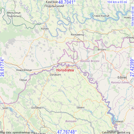
Horodiștea GPS coordinates[2]
48° 14' 16.548" North, 26° 43' 15.096" East
| Map corner | latitude | longitude |
|---|---|---|
| Upper-left | 48.7041°, | 26.01774° |
| Center: | 48.23793°, | 26.72086° |
| Lower-right: | 47.76748°, | 27.42399° |
| Map W x H: | 104.1×104.1 km | = 64.7×64.7mi |
| max Lat: | 48.23793° ⇑0% North |
| Horodiștea: | 48.23793° |
| min Lat: | ⇓100% South 43.65638° |
| min Long | Horodiștea | max Long |
| 20.31667° | 26.72086° | 29.65403° |
| W 77.1%⇐ | ⇒22.9% E |
Elevation
Elevation of Horodiștea is 187 m = 614 ft, and this is 67.9 m = 223 ft below average elevation for this country.
| Max E: |
1278 m = 4193 ft | 55% |
| Avg. | 254.9 m = 836 ft | |
| Horodiștea | 187 m = 614 ft | |
Min E: |
-2 m = -7 ft | 45% |
See also: Romania elevation on elevation.city.
Geographical zone
Horodiștea is located in North temperate zone (between Tropic of Cancer and the Arctic Circle). Distance of this North polar circle is 2037.6 km =1266.1 mi to North.| Distance of | km | miles | from Horodiștea |
|---|---|---|---|
| North Pole | 4643.5 | 2885.3 | to North |
| Arctic Circle | 2037.6 | 1266.1 | to North |
| Tropic Cancer | 2757.6 | 1713.5 | to South |
| Equator | 5363.6 | 3332.8 | to South |


Nearby cities:
15 places around Horodiștea: (largest is in red/bold)
• Bajura
14 km =8.7 mi,  253°
253°
• Codreni
16.7 km =10.4 mi,  163°
163°
• Conceşti
14.9 km =9.3 mi,  237°
237°
• Coţuşca
15.1 km =9.4 mi,  140°
140°
• Cuza Vodă
6 km =3.7 mi,  197°
197°
• Darabani
11.9 km =7.4 mi, 239°
• Ghireni
15.5 km =9.6 mi,  127°
127°
• Lișmănița
11.9 km =7.4 mi, 203°
• Miorcani
10.5 km =6.5 mi,  112°
112°
• Puțureni
16.2 km =10.1 mi,  148°
148°
• Păltiniş
5.8 km =3.6 mi, 245°
• Rediu
4.3 km =2.7 mi,  100°
100°
• Rădăuți-Prut
5.9 km =3.7 mi,  94°
94°
• Viişoara
8 km =5 mi,  173°
173°
• Viișoara Mică
10.6 km =6.6 mi, 152°
Sources, notices
• [Note1] Compared only with cities in Romania existing in our database
• [Src1] Map data: © OpenStreetMap contributors (CC-BY-SA)
• [Src2] Other city data from geonames.org with taken over terms of usage.
• [Src3] Geographical zone / Annual Mean Temperature by Robert A. Rohde @ Wikipedia
