Mătrici geodata
Mătrici (Mureş) is a populated place; located in Romania in Europe/Bucharest (GMT+3) time zone. With population of 795 people, there are 5074 cities with bigger population in this country. Compared to other cities in Romania, 70.7% of cities are located further ↓South; 54% of cities are located further →East and 86.7% of cities have lower elevation than Mătrici. Note1


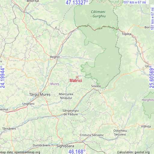
Mătrici GPS coordinates[2]
46° 39' 10.044" North, 24° 54' 9.216" East
| Map corner | latitude | longitude |
|---|---|---|
| Upper-left | 47.13327°, | 24.19944° |
| Center: | 46.65279°, | 24.90256° |
| Lower-right: | 46.168°, | 25.60569° |
| Map W x H: | 107.3×107.3 km | = 66.7×66.7mi |
| max Lat: | 48.23793° ⇑29.3% North |
| Mătrici: | 46.65279° |
| min Lat: | ⇓70.7% South 43.65638° |
| min Long | Mătrici | max Long |
| 20.31667° | 24.90256° | 29.65403° |
| W 46%⇐ | ⇒54% E |
Elevation
Elevation of Mătrici is 466 m = 1529 ft, and this is 211.1 m = 693 ft above average elevation for this country.
| Max E: |
1278 m = 4193 ft | 13.3% |
| Mătrici | 466 m 1529 ft | |
| Avg. | 254.9 m = 836 ft | |
Min E: |
-2 m = -7 ft | 86.7% |
See also: Romania elevation on elevation.city.
Geographical zone
Mătrici is located in North temperate zone (between Tropic of Cancer and the Arctic Circle). Distance of this North polar circle is 2213.9 km =1375.7 mi to North.| Distance of | km | miles | from Mătrici |
|---|---|---|---|
| North Pole | 4819.8 | 2994.9 | to North |
| Arctic Circle | 2213.9 | 1375.7 | to North |
| Tropic Cancer | 2581.4 | 1604 | to South |
| Equator | 5187.3 | 3223.2 | to South |


Nearby cities:
15 places around Mătrici: (largest is in red/bold)
• Beica de Jos
11.9 km =7.4 mi,  318°
318°
• Bereni
10.9 km =6.8 mi,  193°
193°
• Chiheru de Jos
3.7 km =2.3 mi,  336°
336°
• Călugăreni
3 km =1.9 mi,  215°
215°
• Eremitu
2.8 km =1.7 mi,  56°
56°
• Hodac
12.7 km =7.9 mi,  4°
4°
• Hodoşa
6.9 km =4.3 mi,  251°
251°
• Măgherani
9.6 km =6 mi,  181°
181°
• Orșova
10.8 km =6.7 mi, 4°
• Petrilaca de Mureș
12.1 km =7.5 mi,  289°
289°
• Săcădat
12.6 km =7.8 mi,  104°
104°
• Urisiu de Sus
6 km =3.7 mi,  6°
6°
• Valea
12.8 km =8 mi, 219°
• Vărgata
12.4 km =7.7 mi, 219°
• Șilea Nirajului
6.2 km =3.9 mi,  165°
165°
Sources, notices
• [Note1] Compared only with cities in Romania existing in our database
• [Src1] Map data: © OpenStreetMap contributors (CC-BY-SA)
• [Src2] Other city data from geonames.org with taken over terms of usage.
• [Src3] Geographical zone / Annual Mean Temperature by Robert A. Rohde @ Wikipedia
