Măgherani geodata
Măgherani (Mureş) is a seat of a second-order administrative division; located in Romania in Europe/Bucharest (GMT+3) time zone. With population of 2,681 people, there are 1995 cities with bigger population in this country. Compared to other cities in Romania, 68.5% of cities are located further ↓South; 54.1% of cities are located further →East and 79.9% of cities have lower elevation than Măgherani. Note1


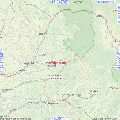
Măgherani GPS coordinates[2]
46° 34' 0.012" North, 24° 54' 0" East
| Map corner | latitude | longitude |
|---|---|---|
| Upper-left | 47.04792°, | 24.19688° |
| Center: | 46.56667°, | 24.9° |
| Lower-right: | 46.08111°, | 25.60313° |
| Map W x H: | 107.5×107.5 km | = 66.8×66.8mi |
| max Lat: | 48.23793° ⇑31.5% North |
| Măgherani: | 46.56667° |
| min Lat: | ⇓68.5% South 43.65638° |
| min Long | Măgherani | max Long |
| 20.31667° | 24.9° | 29.65403° |
| W 45.9%⇐ | ⇒54.1% E |
Elevation
Elevation of Măgherani is 393 m = 1289 ft, and this is 138.1 m = 453 ft above average elevation for this country.
| Max E: |
1278 m = 4193 ft | 20.1% |
| Măgherani | 393 m 1289 ft | |
| Avg. | 254.9 m = 836 ft | |
Min E: |
-2 m = -7 ft | 79.9% |
See also: Romania elevation on elevation.city.
Geographical zone
Măgherani is located in North temperate zone (between Tropic of Cancer and the Arctic Circle). Distance of this North polar circle is 2223.4 km =1381.6 mi to North.| Distance of | km | miles | from Măgherani |
|---|---|---|---|
| North Pole | 4829.3 | 3000.8 | to North |
| Arctic Circle | 2223.4 | 1381.6 | to North |
| Tropic Cancer | 2571.8 | 1598 | to South |
| Equator | 5177.7 | 3217.3 | to South |


Nearby cities:
15 places around Măgherani: (largest is in red/bold)
• Bereni
2.6 km =1.6 mi,  246°
246°
• Chibed
6 km =3.7 mi,  127°
127°
• Călugăreni
7.3 km =4.5 mi,  347°
347°
• Eremitu
11.4 km =7.1 mi,  12°
12°
• Ghindari
7.5 km =4.7 mi,  170°
170°
• Găleşti
12.7 km =7.9 mi,  244°
244°
• Hodoşa
9.8 km =6.1 mi,  319°
319°
• Miercurea Nirajului
8.5 km =5.3 mi, 244°
• Mătrici
9.6 km =6 mi,  1°
1°
• Neaua
10.6 km =6.6 mi,  208°
208°
• Sărățeni
8.7 km =5.4 mi,  93°
93°
• Trei Sate
10.1 km =6.3 mi,  180°
180°
• Valea
7.9 km =4.9 mi,  267°
267°
• Vărgata
7.6 km =4.7 mi, 270°
• Șilea Nirajului
4 km =2.5 mi,  26°
26°
Sources, notices
• [Note1] Compared only with cities in Romania existing in our database
• [Src1] Map data: © OpenStreetMap contributors (CC-BY-SA)
• [Src2] Other city data from geonames.org with taken over terms of usage.
• [Src3] Geographical zone / Annual Mean Temperature by Robert A. Rohde @ Wikipedia
