Malu Vânăt geodata
Malu Vânăt (Prahova) is a populated place; located in Romania in Europe/Bucharest (GMT+3) time zone. With population of 884 people, there are 4685 cities with bigger population in this country. Compared to other cities in Romania, 60.1% of cities are located further ↑North; 63.5% of cities are located further ←West and 86.5% of cities have lower elevation than Malu Vânăt. Note1


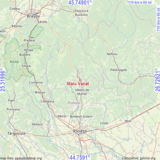
Malu Vânăt GPS coordinates[2]
45° 15' 22.356" North, 26° 1' 23.088" East
| Map corner | latitude | longitude |
|---|---|---|
| Upper-left | 45.74901°, | 25.31996° |
| Center: | 45.25621°, | 26.02308° |
| Lower-right: | 44.7591°, | 26.72621° |
| Map W x H: | 110.1×110.1 km | = 68.4×68.4mi |
| max Lat: | 48.23793° ⇑60.1% North |
| Malu Vânăt: | 45.25621° |
| min Lat: | ⇓39.9% South 43.65638° |
| min Long | Malu Vânăt | max Long |
| 20.31667° | 26.02308° | 29.65403° |
| W 63.5%⇐ | ⇒36.5% E |
Elevation
Elevation of Malu Vânăt is 463 m = 1519 ft, and this is 208.1 m = 683 ft above average elevation for this country.
| Max E: |
1278 m = 4193 ft | 13.5% |
| Malu Vânăt | 463 m 1519 ft | |
| Avg. | 254.9 m = 836 ft | |
Min E: |
-2 m = -7 ft | 86.5% |
See also: Romania elevation on elevation.city.
Geographical zone
Malu Vânăt is located in North temperate zone (between Tropic of Cancer and the Arctic Circle). Distance of this North polar circle is 2369.2 km =1472.2 mi to North.| Distance of | km | miles | from Malu Vânăt |
|---|---|---|---|
| North Pole | 4975 | 3091.3 | to North |
| Arctic Circle | 2369.2 | 1472.2 | to North |
| Tropic Cancer | 2426.1 | 1507.5 | to South |
| Equator | 5032 | 3126.7 | to South |


Nearby cities:
15 places around Malu Vânăt: (largest is in red/bold)
• Ceraşu
6.8 km =4.2 mi,  6°
6°
• Drajna de Jos
4.9 km =3 mi,  154°
154°
• Drajna de Sus
4 km =2.5 mi,  88°
88°
• Făcăieni
5.8 km =3.6 mi,  338°
338°
• Gheaba
6 km =3.7 mi,  347°
347°
• Groșani
5.9 km =3.7 mi,  261°
261°
• Homorâciu
1.6 km =1 mi, 340°
• Izvoarele
3.5 km =2.2 mi,  330°
330°
• Ogretin
5.5 km =3.4 mi,  79°
79°
• Olteni
3.5 km =2.2 mi,  192°
192°
• Schiulești
6.3 km =3.9 mi,  300°
300°
• Teişani
4 km =2.5 mi,  230°
230°
• Valea Borului
5.6 km =3.5 mi, 11°
• Valea Stâlpului
5 km =3.1 mi, 186°
• Ștubeiu
4 km =2.5 mi, 186°
Sources, notices
• [Note1] Compared only with cities in Romania existing in our database
• [Src1] Map data: © OpenStreetMap contributors (CC-BY-SA)
• [Src2] Other city data from geonames.org with taken over terms of usage.
• [Src3] Geographical zone / Annual Mean Temperature by Robert A. Rohde @ Wikipedia
