Ceraşu geodata
Ceraşu (Prahova) is a seat of a second-order administrative division; located in Romania in Europe/Bucharest (GMT+3) time zone. With population of 5,105 people, there are 745 cities with bigger population in this country. Compared to other cities in Romania, 58.6% of cities are located further ↑North; 63.6% of cities are located further ←West and 92.8% of cities have lower elevation than Ceraşu. Note1


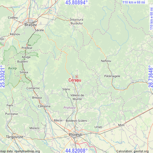
Ceraşu GPS coordinates[2]
45° 19' 0.012" North, 26° 1' 59.988" East
| Map corner | latitude | longitude |
|---|---|---|
| Upper-left | 45.80894°, | 25.33021° |
| Center: | 45.31667°, | 26.03333° |
| Lower-right: | 44.82008°, | 26.73646° |
| Map W x H: | 110×109.9 km | = 68.4×68.3mi |
| max Lat: | 48.23793° ⇑58.6% North |
| Ceraşu: | 45.31667° |
| min Lat: | ⇓41.4% South 43.65638° |
| min Long | Ceraşu | max Long |
| 20.31667° | 26.03333° | 29.65403° |
| W 63.6%⇐ | ⇒36.4% E |
Elevation
Elevation of Ceraşu is 564 m = 1850 ft, and this is 309.1 m = 1014 ft above average elevation for this country.
| Max E: |
1278 m = 4193 ft | 7.2% |
| Ceraşu | 564 m 1850 ft | |
| Avg. | 254.9 m = 836 ft | |
Min E: |
-2 m = -7 ft | 92.8% |
See also: Romania elevation on elevation.city.
Geographical zone
Ceraşu is located in North temperate zone (between Tropic of Cancer and the Arctic Circle). Distance of this North polar circle is 2362.4 km =1467.9 mi to North.| Distance of | km | miles | from Ceraşu |
|---|---|---|---|
| North Pole | 4968.3 | 3087.2 | to North |
| Arctic Circle | 2362.4 | 1467.9 | to North |
| Tropic Cancer | 2432.8 | 1511.7 | to South |
| Equator | 5038.7 | 3130.9 | to South |


Nearby cities:
15 places around Ceraşu: (largest is in red/bold)
• Bătrâni
9.2 km =5.7 mi,  91°
91°
• Drajna de Sus
7.3 km =4.5 mi,  154°
154°
• Făcăieni
3.2 km =2 mi,  245°
245°
• Gheaba
2.3 km =1.4 mi, 248°
• Homorâciu
5.4 km =3.4 mi,  194°
194°
• Izvoarele
4.4 km =2.7 mi,  214°
214°
• Malu Vânăt
6.8 km =4.2 mi, 186°
• Măneciu-Ungureni
3.9 km =2.4 mi,  270°
270°
• Nucșoara de Jos
6.5 km =4 mi,  115°
115°
• Nucșoara de Sus
7.4 km =4.6 mi, 121°
• Ogretin
7.4 km =4.6 mi,  141°
141°
• Schiulești
7.1 km =4.4 mi,  240°
240°
• Slon
4.3 km =2.7 mi,  8°
8°
• Teişani
10.1 km =6.3 mi,  202°
202°
• Valea Borului
1.2 km =0.7 mi,  164°
164°
Sources, notices
• [Note1] Compared only with cities in Romania existing in our database
• [Src1] Map data: © OpenStreetMap contributors (CC-BY-SA)
• [Src2] Other city data from geonames.org with taken over terms of usage.
• [Src3] Geographical zone / Annual Mean Temperature by Robert A. Rohde @ Wikipedia
