Măgura geodata
Măgura (Buzău) is a seat of a second-order administrative division; located in Romania in Europe/Bucharest (GMT+3) time zone. With population of 4,657 people, there are 897 cities with bigger population in this country. Compared to other cities in Romania, 59.9% of cities are located further ↑North; 74.3% of cities are located further ←West and 57.3% of cities have lower elevation than Măgura. Note1


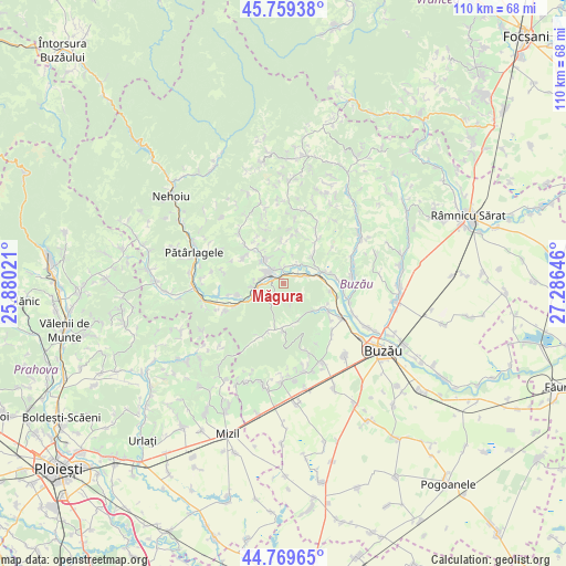
Măgura GPS coordinates[2]
45° 16' 0.012" North, 26° 34' 59.988" East
| Map corner | latitude | longitude |
|---|---|---|
| Upper-left | 45.75938°, | 25.88021° |
| Center: | 45.26667°, | 26.58333° |
| Lower-right: | 44.76965°, | 27.28646° |
| Map W x H: | 110×110 km | = 68.4×68.4mi |
| max Lat: | 48.23793° ⇑59.9% North |
| Măgura: | 45.26667° |
| min Lat: | ⇓40.1% South 43.65638° |
| min Long | Măgura | max Long |
| 20.31667° | 26.58333° | 29.65403° |
| W 74.3%⇐ | ⇒25.7% E |
Elevation
Elevation of Măgura is 249 m = 817 ft, and this is 5.9 m = 19 ft below average elevation for this country.
| Max E: |
1278 m = 4193 ft | 42.7% |
| Avg. | 254.9 m = 836 ft | |
| Măgura | 249 m = 817 ft | |
Min E: |
-2 m = -7 ft | 57.3% |
See also: Romania elevation on elevation.city.
Geographical zone
Măgura is located in North temperate zone (between Tropic of Cancer and the Arctic Circle). Distance of this North polar circle is 2368 km =1471.4 mi to North.| Distance of | km | miles | from Măgura |
|---|---|---|---|
| North Pole | 4973.9 | 3090.6 | to North |
| Arctic Circle | 2368 | 1471.4 | to North |
| Tropic Cancer | 2427.3 | 1508.3 | to South |
| Equator | 5033.2 | 3127.5 | to South |


Nearby cities:
15 places around Măgura: (largest is in red/bold)
• Badila
5.7 km =3.5 mi,  269°
269°
• Berca
8 km =5 mi,  76°
76°
• Ciuta
4.8 km =3 mi,  262°
262°
• Grăjdana
7.5 km =4.7 mi,  149°
149°
• Haleș
8.6 km =5.3 mi,  191°
191°
• Izvoru
8.3 km =5.2 mi,  175°
175°
• Joseni
7.6 km =4.7 mi,  48°
48°
• Lunca Frumoasă
5.6 km =3.5 mi,  322°
322°
• Nișcov
9.3 km =5.8 mi,  119°
119°
• Pârscov
3.2 km =2 mi,  305°
305°
• Pălici
9.2 km =5.7 mi, 256°
• Rătești
5.9 km =3.7 mi,  55°
55°
• Sătuc
7.1 km =4.4 mi, 79°
• Unguriu
4.1 km =2.5 mi,  69°
69°
• Valea Sălciilor
7.9 km =4.9 mi,  164°
164°
Sources, notices
• [Note1] Compared only with cities in Romania existing in our database
• [Src1] Map data: © OpenStreetMap contributors (CC-BY-SA)
• [Src2] Other city data from geonames.org with taken over terms of usage.
• [Src3] Geographical zone / Annual Mean Temperature by Robert A. Rohde @ Wikipedia
