Grăjdana geodata
Grăjdana (Buzău) is a populated place; located in Romania in Europe/Bucharest (GMT+3) time zone. With population of 1,008 people, there are 4272 cities with bigger population in this country. Compared to other cities in Romania, 61.4% of cities are located further ↑North; 75.1% of cities are located further ←West and 60.6% of cities have higher elevation than Grăjdana. Note1


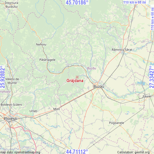
Grăjdana GPS coordinates[2]
45° 12' 31.14" North, 26° 37' 52.104" East
| Map corner | latitude | longitude |
|---|---|---|
| Upper-left | 45.70186°, | 25.92802° |
| Center: | 45.20865°, | 26.63114° |
| Lower-right: | 44.71112°, | 27.33427° |
| Map W x H: | 110.2×110.2 km | = 68.5×68.5mi |
| max Lat: | 48.23793° ⇑61.4% North |
| Grăjdana: | 45.20865° |
| min Lat: | ⇓38.6% South 43.65638° |
| min Long | Grăjdana | max Long |
| 20.31667° | 26.63114° | 29.65403° |
| W 75.1%⇐ | ⇒24.9% E |
Elevation
Elevation of Grăjdana is 164 m = 538 ft, and this is 90.9 m = 298 ft below average elevation for this country.
| Max E: |
1278 m = 4193 ft | 60.6% |
| Avg. | 254.9 m = 836 ft | |
| Grăjdana | 164 m = 538 ft | |
Min E: |
-2 m = -7 ft | 39.4% |
See also: Romania elevation on elevation.city.
Geographical zone
Grăjdana is located in North temperate zone (between Tropic of Cancer and the Arctic Circle). Distance of this North polar circle is 2374.4 km =1475.4 mi to North.| Distance of | km | miles | from Grăjdana |
|---|---|---|---|
| North Pole | 4980.3 | 3094.6 | to North |
| Arctic Circle | 2374.4 | 1475.4 | to North |
| Tropic Cancer | 2420.8 | 1504.2 | to South |
| Equator | 5026.7 | 3123.4 | to South |


Nearby cities:
15 places around Grăjdana: (largest is in red/bold)
• Berca
9.3 km =5.8 mi,  26°
26°
• Haleș
5.8 km =3.6 mi,  250°
250°
• Izvoru
3.6 km =2.2 mi,  239°
239°
• Merei
9.3 km =5.8 mi,  153°
153°
• Măgura
7.5 km =4.7 mi,  329°
329°
• Mătești
9.8 km =6.1 mi,  86°
86°
• Nișcov
4.7 km =2.9 mi,  66°
66°
• Rătești
9.8 km =6.1 mi,  6°
6°
• Sărata-Monteoru
6.6 km =4.1 mi,  172°
172°
• Sătuc
8.4 km =5.2 mi,  22°
22°
• Unguriu
7.9 km =4.9 mi,  0°
0°
• Valea Nucului
9.5 km =5.9 mi,  54°
54°
• Valea Sălciilor
2 km =1.2 mi,  233°
233°
• Verneşti
8.1 km =5 mi,  83°
83°
• Zorești
6.4 km =4 mi,  117°
117°
Sources, notices
• [Note1] Compared only with cities in Romania existing in our database
• [Src1] Map data: © OpenStreetMap contributors (CC-BY-SA)
• [Src2] Other city data from geonames.org with taken over terms of usage.
• [Src3] Geographical zone / Annual Mean Temperature by Robert A. Rohde @ Wikipedia
