Lungani geodata
Lungani (Iaşi) is a seat of a second-order administrative division; located in Romania in Europe/Bucharest (GMT+3) time zone. With population of 5,065 people, there are 763 cities with bigger population in this country. Compared to other cities in Romania, 83.4% of cities are located further ↓South; 86% of cities are located further ←West and 75.4% of cities have higher elevation than Lungani. Note1


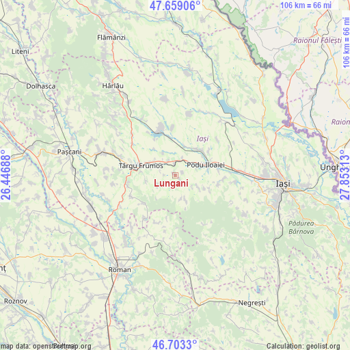
Lungani GPS coordinates[2]
47° 10' 59.988" North, 27° 9' 0" East
| Map corner | latitude | longitude |
|---|---|---|
| Upper-left | 47.65906°, | 26.44688° |
| Center: | 47.18333°, | 27.15° |
| Lower-right: | 46.7033°, | 27.85313° |
| Map W x H: | 106.3×106.3 km | = 66.1×66.1mi |
| max Lat: | 48.23793° ⇑16.6% North |
| Lungani: | 47.18333° |
| min Lat: | ⇓83.4% South 43.65638° |
| min Long | Lungani | max Long |
| 20.31667° | 27.15° | 29.65403° |
| W 86%⇐ | ⇒14% E |
Elevation
Elevation of Lungani is 109 m = 358 ft, and this is 145.9 m = 479 ft below average elevation for this country.
| Max E: |
1278 m = 4193 ft | 75.4% |
| Avg. | 254.9 m = 836 ft | |
| Lungani | 109 m = 358 ft | |
Min E: |
-2 m = -7 ft | 24.6% |
See also: Romania elevation on elevation.city.
Geographical zone
Lungani is located in North temperate zone (between Tropic of Cancer and the Arctic Circle). Distance of this North polar circle is 2154.9 km =1339 mi to North.| Distance of | km | miles | from Lungani |
|---|---|---|---|
| North Pole | 4760.8 | 2958.2 | to North |
| Arctic Circle | 2154.9 | 1339 | to North |
| Tropic Cancer | 2640.4 | 1640.7 | to South |
| Equator | 5246.3 | 3259.9 | to South |


Nearby cities:
15 places around Lungani: (largest is in red/bold)
• Brăeşti
5.3 km =3.3 mi,  225°
225°
• Budăi
6.7 km =4.2 mi,  55°
55°
• Bălţaţi
3.7 km =2.3 mi,  0°
0°
• Cristești
5.7 km =3.5 mi,  245°
245°
• Crucea
2.5 km =1.6 mi,  141°
141°
• Goești
3.1 km =1.9 mi,  198°
198°
• Ion Neculce
7.7 km =4.8 mi,  286°
286°
• Popeşti
7.3 km =4.5 mi,  120°
120°
• Prigoreni
6.7 km =4.2 mi, 293°
• Războieni
8.4 km =5.2 mi,  296°
296°
• Sineşti
7.8 km =4.8 mi,  161°
161°
• Stornești
7.8 km =4.8 mi, 161°
• Sârca
5.6 km =3.5 mi,  24°
24°
• Valea Oilor
7.6 km =4.7 mi,  331°
331°
• Zmeu
2.4 km =1.5 mi,  67°
67°
Sources, notices
• [Note1] Compared only with cities in Romania existing in our database
• [Src1] Map data: © OpenStreetMap contributors (CC-BY-SA)
• [Src2] Other city data from geonames.org with taken over terms of usage.
• [Src3] Geographical zone / Annual Mean Temperature by Robert A. Rohde @ Wikipedia
