Războieni geodata
Războieni (Iaşi) is a populated place; located in Romania in Europe/Bucharest (GMT+3) time zone. With population of 1,200 people, there are 3744 cities with bigger population in this country. Compared to other cities in Romania, 84.5% of cities are located further ↓South; 84% of cities are located further ←West and 76.3% of cities have higher elevation than Războieni. Note1


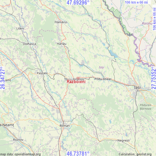
Războieni GPS coordinates[2]
47° 13' 3.144" North, 27° 3' 1.404" East
| Map corner | latitude | longitude |
|---|---|---|
| Upper-left | 47.69296°, | 26.34727° |
| Center: | 47.21754°, | 27.05039° |
| Lower-right: | 46.73781°, | 27.75352° |
| Map W x H: | 106.2×106.2 km | = 66×66mi |
| max Lat: | 48.23793° ⇑15.5% North |
| Războieni: | 47.21754° |
| min Lat: | ⇓84.5% South 43.65638° |
| min Long | Războieni | max Long |
| 20.31667° | 27.05039° | 29.65403° |
| W 84%⇐ | ⇒16% E |
Elevation
Elevation of Războieni is 106 m = 348 ft, and this is 148.9 m = 489 ft below average elevation for this country.
| Max E: |
1278 m = 4193 ft | 76.3% |
| Avg. | 254.9 m = 836 ft | |
| Războieni | 106 m = 348 ft | |
Min E: |
-2 m = -7 ft | 23.7% |
See also: Romania elevation on elevation.city.
Geographical zone
Războieni is located in North temperate zone (between Tropic of Cancer and the Arctic Circle). Distance of this North polar circle is 2151.1 km =1336.6 mi to North.| Distance of | km | miles | from Războieni |
|---|---|---|---|
| North Pole | 4757 | 2955.9 | to North |
| Arctic Circle | 2151.1 | 1336.6 | to North |
| Tropic Cancer | 2644.2 | 1643 | to South |
| Equator | 5250.1 | 3262.3 | to South |


Nearby cities:
15 places around Războieni: (largest is in red/bold)
• Boureni
7.7 km =4.8 mi,  313°
313°
• Brăeşti
8.4 km =5.2 mi,  153°
153°
• Buznea
3.6 km =2.2 mi,  226°
226°
• Bălţaţi
7.5 km =4.7 mi,  90°
90°
• Cristești
6.6 km =4.1 mi,  159°
159°
• Goești
9.4 km =5.8 mi,  136°
136°
• Gănești
5.8 km =3.6 mi,  194°
194°
• Ion Neculce
1.6 km =1 mi,  173°
173°
• Liteni
9.4 km =5.8 mi,  354°
354°
• Lungani
8.4 km =5.2 mi,  116°
116°
• Prigoreni
1.7 km =1.1 mi,  129°
129°
• Strunga
7.6 km =4.7 mi,  221°
221°
• Târgu Frumos
4.3 km =2.7 mi,  242°
242°
• Ulmi
7.5 km =4.7 mi,  12°
12°
• Valea Oilor
4.8 km =3 mi,  53°
53°
Sources, notices
• [Note1] Compared only with cities in Romania existing in our database
• [Src1] Map data: © OpenStreetMap contributors (CC-BY-SA)
• [Src2] Other city data from geonames.org with taken over terms of usage.
• [Src3] Geographical zone / Annual Mean Temperature by Robert A. Rohde @ Wikipedia
