Loloiasca geodata
Loloiasca (Prahova) is a populated place; located in Romania in Europe/Bucharest (GMT+3) time zone. With population of 1,575 people, there are 3079 cities with bigger population in this country. Compared to other cities in Romania, 70.7% of cities are located further ↑North; 68.6% of cities are located further ←West and 71.4% of cities have higher elevation than Loloiasca. Note1


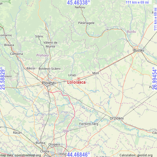
Loloiasca GPS coordinates[2]
44° 58' 5.088" North, 26° 17' 29.076" East
| Map corner | latitude | longitude |
|---|---|---|
| Upper-left | 45.46338°, | 25.58829° |
| Center: | 44.96808°, | 26.29141° |
| Lower-right: | 44.46846°, | 26.99454° |
| Map W x H: | 110.6×110.6 km | = 68.7×68.7mi |
| max Lat: | 48.23793° ⇑70.7% North |
| Loloiasca: | 44.96808° |
| min Lat: | ⇓29.3% South 43.65638° |
| min Long | Loloiasca | max Long |
| 20.31667° | 26.29141° | 29.65403° |
| W 68.6%⇐ | ⇒31.4% E |
Elevation
Elevation of Loloiasca is 122 m = 400 ft, and this is 132.9 m = 436 ft below average elevation for this country.
| Max E: |
1278 m = 4193 ft | 71.4% |
| Avg. | 254.9 m = 836 ft | |
| Loloiasca | 122 m = 400 ft | |
Min E: |
-2 m = -7 ft | 28.6% |
See also: Romania elevation on elevation.city.
Geographical zone
Loloiasca is located in North temperate zone (between Tropic of Cancer and the Arctic Circle). Distance of this Northern Tropic circle is 2394.1 km =1487.6 mi to South.| Distance of | km | miles | from Loloiasca |
|---|---|---|---|
| North Pole | 5007.1 | 3111.3 | to North |
| Arctic Circle | 2401.2 | 1492 | to North |
| Tropic Cancer | 2394.1 | 1487.6 | to South |
| Equator | 5000 | 3106.9 | to South |


Nearby cities:
15 places around Loloiasca: (largest is in red/bold)
• Albeşti-Paleologu
6.2 km =3.9 mi,  251°
251°
• Albești-Muru
7 km =4.3 mi, 247°
• Ceptura de Jos
6.5 km =4 mi,  25°
25°
• Ceptura de Sus
5.8 km =3.6 mi,  20°
20°
• Cioceni
6.7 km =4.2 mi,  183°
183°
• Colceag
5 km =3.1 mi,  113°
113°
• Inotești
5.3 km =3.3 mi,  98°
98°
• Magula
4.1 km =2.5 mi,  169°
169°
• Orzoaia de Jos
6.3 km =3.9 mi,  308°
308°
• Tomşani
2.1 km =1.3 mi,  197°
197°
• Urlaţi
4.9 km =3 mi,  290°
290°
• Vadu Părului
7.6 km =4.7 mi,  237°
237°
• Valea Largă
7.3 km =4.5 mi,  266°
266°
• Valea Pietrei
7.3 km =4.5 mi, 309°
• Vâlcelele
7.8 km =4.8 mi, 114°
Sources, notices
• [Note1] Compared only with cities in Romania existing in our database
• [Src1] Map data: © OpenStreetMap contributors (CC-BY-SA)
• [Src2] Other city data from geonames.org with taken over terms of usage.
• [Src3] Geographical zone / Annual Mean Temperature by Robert A. Rohde @ Wikipedia
