Vâlcelele geodata
Vâlcelele (Prahova) is a populated place; located in Romania in Europe/Bucharest (GMT+3) time zone. With population of 663 people, there are 5791 cities with bigger population in this country. Compared to other cities in Romania, 71.9% of cities are located further ↑North; 70.5% of cities are located further ←West and 79% of cities have higher elevation than Vâlcelele. Note1


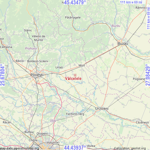
Vâlcelele GPS coordinates[2]
44° 56' 21.264" North, 26° 22' 52.176" East
| Map corner | latitude | longitude |
|---|---|---|
| Upper-left | 45.43479°, | 25.67804° |
| Center: | 44.93924°, | 26.38116° |
| Lower-right: | 44.43937°, | 27.08429° |
| Map W x H: | 110.7×110.7 km | = 68.8×68.8mi |
| max Lat: | 48.23793° ⇑71.9% North |
| Vâlcelele: | 44.93924° |
| min Lat: | ⇓28.1% South 43.65638° |
| min Long | Vâlcelele | max Long |
| 20.31667° | 26.38116° | 29.65403° |
| W 70.5%⇐ | ⇒29.5% E |
Elevation
Elevation of Vâlcelele is 98 m = 322 ft, and this is 156.9 m = 515 ft below average elevation for this country.
| Max E: |
1278 m = 4193 ft | 79% |
| Avg. | 254.9 m = 836 ft | |
| Vâlcelele | 98 m = 322 ft | |
Min E: |
-2 m = -7 ft | 21% |
See also: Romania elevation on elevation.city.
Geographical zone
Vâlcelele is located in North temperate zone (between Tropic of Cancer and the Arctic Circle). Distance of this Northern Tropic circle is 2390.9 km =1485.6 mi to South.| Distance of | km | miles | from Vâlcelele |
|---|---|---|---|
| North Pole | 5010.3 | 3113.3 | to North |
| Arctic Circle | 2404.4 | 1494 | to North |
| Tropic Cancer | 2390.9 | 1485.6 | to South |
| Equator | 4996.8 | 3104.9 | to South |


Nearby cities:
15 places around Vâlcelele: (largest is in red/bold)
• Baba Ana
6.2 km =3.9 mi,  60°
60°
• Bărăitaru
9 km =5.6 mi,  195°
195°
• Ceptura de Sus
10 km =6.2 mi,  329°
329°
• Cioceni
8.3 km =5.2 mi,  245°
245°
• Colceag
2.7 km =1.7 mi,  296°
296°
• Conduratu
5.5 km =3.4 mi,  48°
48°
• Fefelei
9.5 km =5.9 mi,  30°
30°
• Fulga de Jos
8 km =5 mi,  142°
142°
• Fulga de Sus
7 km =4.3 mi,  128°
128°
• Fântânele
7.5 km =4.7 mi,  357°
357°
• Inotești
3.1 km =1.9 mi,  323°
323°
• Loloiasca
7.8 km =4.8 mi,  294°
294°
• Magula
6.4 km =4 mi,  262°
262°
• Parepa-Rușani
4.3 km =2.7 mi,  209°
209°
• Tomşani
7.8 km =4.8 mi,  278°
278°
Sources, notices
• [Note1] Compared only with cities in Romania existing in our database
• [Src1] Map data: © OpenStreetMap contributors (CC-BY-SA)
• [Src2] Other city data from geonames.org with taken over terms of usage.
• [Src3] Geographical zone / Annual Mean Temperature by Robert A. Rohde @ Wikipedia
