Lera geodata
Lera (Buzău) is a populated place; located in Romania in Europe/Bucharest (GMT+3) time zone. With population of 525 people, there are 6818 cities with bigger population in this country. Compared to other cities in Romania, 58.1% of cities are located further ↑North; 67.6% of cities are located further ←West and 84.7% of cities have lower elevation than Lera. Note1


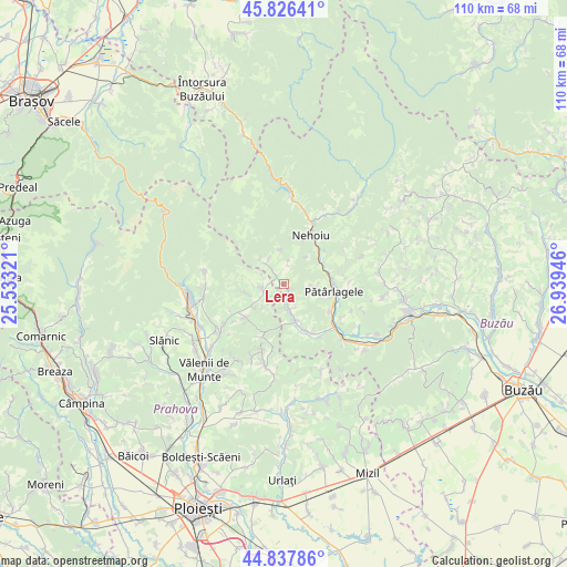
Lera GPS coordinates[2]
45° 20' 3.444" North, 26° 14' 10.788" East
| Map corner | latitude | longitude |
|---|---|---|
| Upper-left | 45.82641°, | 25.53321° |
| Center: | 45.33429°, | 26.23633° |
| Lower-right: | 44.83786°, | 26.93946° |
| Map W x H: | 109.9×109.9 km | = 68.3×68.3mi |
| max Lat: | 48.23793° ⇑58.1% North |
| Lera: | 45.33429° |
| min Lat: | ⇓41.9% South 43.65638° |
| min Long | Lera | max Long |
| 20.31667° | 26.23633° | 29.65403° |
| W 67.6%⇐ | ⇒32.4% E |
Elevation
Elevation of Lera is 443 m = 1453 ft, and this is 188.1 m = 617 ft above average elevation for this country.
| Max E: |
1278 m = 4193 ft | 15.3% |
| Lera | 443 m 1453 ft | |
| Avg. | 254.9 m = 836 ft | |
Min E: |
-2 m = -7 ft | 84.7% |
See also: Romania elevation on elevation.city.
Geographical zone
Lera is located in North temperate zone (between Tropic of Cancer and the Arctic Circle). Distance of this North polar circle is 2360.5 km =1466.7 mi to North.| Distance of | km | miles | from Lera |
|---|---|---|---|
| North Pole | 4966.4 | 3086 | to North |
| Arctic Circle | 2360.5 | 1466.7 | to North |
| Tropic Cancer | 2434.8 | 1512.9 | to South |
| Equator | 5040.7 | 3132.1 | to South |


Nearby cities:
15 places around Lera: (largest is in red/bold)
• Burueneşti
9.1 km =5.7 mi,  102°
102°
• Bâsca Chiojdului
5.8 km =3.6 mi,  314°
314°
• Bâscenii de Sus
8 km =5 mi,  160°
160°
• Bătrâni
7 km =4.3 mi,  251°
251°
• Chiojdu
3.3 km =2.1 mi,  301°
301°
• Corbu
1.8 km =1.1 mi,  145°
145°
• Crâng
9.1 km =5.7 mi, 102°
• Cătiașu
6.7 km =4.2 mi,  354°
354°
• Cătina
4 km =2.5 mi, 164°
• Mlăjet
8.9 km =5.5 mi,  58°
58°
• Starchiojd
4.6 km =2.9 mi,  244°
244°
• Valea Anei
4.4 km =2.7 mi,  225°
225°
• Valea Cătinei
4.7 km =2.9 mi,  180°
180°
• Valea Lupului
8.7 km =5.4 mi,  77°
77°
• Valea Plopului
6.9 km =4.3 mi, 231°
Sources, notices
• [Note1] Compared only with cities in Romania existing in our database
• [Src1] Map data: © OpenStreetMap contributors (CC-BY-SA)
• [Src2] Other city data from geonames.org with taken over terms of usage.
• [Src3] Geographical zone / Annual Mean Temperature by Robert A. Rohde @ Wikipedia
