Lanurile geodata
Lanurile (Constanța) is a populated place; located in Romania in Europe/Bucharest (GMT+3) time zone. With population of 885 people, there are 4678 cities with bigger population in this country. Compared to other cities in Romania, 95.9% of cities are located further ↑North; 98.3% of cities are located further ←West and 79.2% of cities have higher elevation than Lanurile. Note1


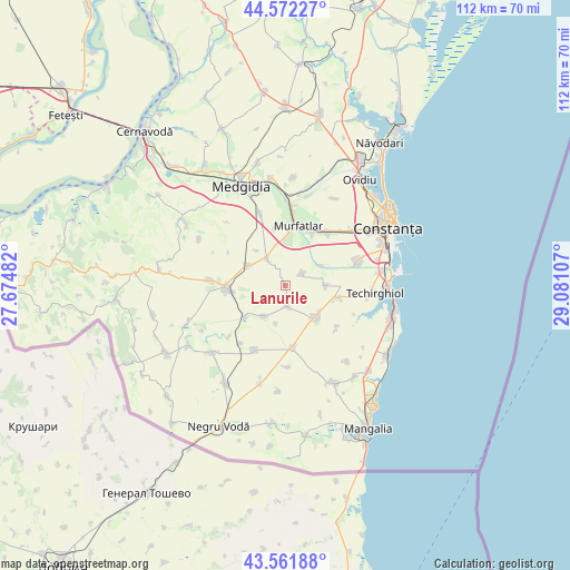
Lanurile GPS coordinates[2]
44° 4' 9.228" North, 28° 22' 40.584" East
| Map corner | latitude | longitude |
|---|---|---|
| Upper-left | 44.57227°, | 27.67482° |
| Center: | 44.06923°, | 28.37794° |
| Lower-right: | 43.56188°, | 29.08107° |
| Map W x H: | 112.3×112.3 km | = 69.8×69.8mi |
| max Lat: | 48.23793° ⇑95.9% North |
| Lanurile: | 44.06923° |
| min Lat: | ⇓4.1% South 43.65638° |
| min Long | Lanurile | max Long |
| 20.31667° | 28.37794° | 29.65403° |
| W 98.3%⇐ | ⇒1.7% E |
Elevation
Elevation of Lanurile is 97 m = 318 ft, and this is 157.9 m = 518 ft below average elevation for this country.
| Max E: |
1278 m = 4193 ft | 79.2% |
| Avg. | 254.9 m = 836 ft | |
| Lanurile | 97 m = 318 ft | |
Min E: |
-2 m = -7 ft | 20.8% |
See also: Romania elevation on elevation.city.
Geographical zone
Lanurile is located in North temperate zone (between Tropic of Cancer and the Arctic Circle). Distance of this Northern Tropic circle is 2294.1 km =1425.5 mi to South.| Distance of | km | miles | from Lanurile |
|---|---|---|---|
| North Pole | 5107 | 3173.3 | to North |
| Arctic Circle | 2501.1 | 1554.1 | to North |
| Tropic Cancer | 2294.1 | 1425.5 | to South |
| Equator | 4900 | 3044.7 | to South |


Nearby cities:
15 places around Lanurile: (largest is in red/bold)
• Amzacea
13.4 km =8.3 mi,  172°
172°
• Biruința
13.2 km =8.2 mi,  128°
128°
• Bărăganu
4 km =2.5 mi,  56°
56°
• Ciocârlia
8.3 km =5.2 mi,  294°
294°
• Ciocârlia de Sus
6.4 km =4 mi,  326°
326°
• Cobadin
13 km =8.1 mi,  276°
276°
• General Scărișoreanu
14.2 km =8.8 mi,  205°
205°
• Mereni
2.3 km =1.4 mi,  202°
202°
• Movilița
11 km =6.8 mi,  104°
104°
• Murfatlar
13.1 km =8.1 mi,  13°
13°
• Osmancea
7.5 km =4.7 mi,  215°
215°
• Siminoc
11.2 km =7 mi,  349°
349°
• Topraisar
8.2 km =5.1 mi,  135°
135°
• Valu lui Traian
12.9 km =8 mi,  33°
33°
• Viișoara
14.7 km =9.1 mi,  273°
273°
Sources, notices
• [Note1] Compared only with cities in Romania existing in our database
• [Src1] Map data: © OpenStreetMap contributors (CC-BY-SA)
• [Src2] Other city data from geonames.org with taken over terms of usage.
• [Src3] Geographical zone / Annual Mean Temperature by Robert A. Rohde @ Wikipedia
