Osmancea geodata
Osmancea (Constanța) is a populated place; located in Romania in Europe/Bucharest (GMT+3) time zone. With population of 599 people, there are 6213 cities with bigger population in this country. Compared to other cities in Romania, 96.8% of cities are located further ↑North; 98.1% of cities are located further ←West and 87.6% of cities have higher elevation than Osmancea. Note1


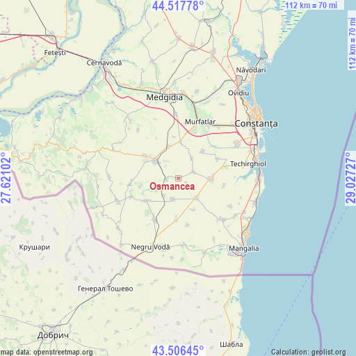
Osmancea GPS coordinates[2]
44° 0' 51.372" North, 28° 19' 26.904" East
| Map corner | latitude | longitude |
|---|---|---|
| Upper-left | 44.51778°, | 27.62102° |
| Center: | 44.01427°, | 28.32414° |
| Lower-right: | 43.50645°, | 29.02727° |
| Map W x H: | 112.4×112.4 km | = 69.8×69.8mi |
| max Lat: | 48.23793° ⇑96.8% North |
| Osmancea: | 44.01427° |
| min Lat: | ⇓3.2% South 43.65638° |
| min Long | Osmancea | max Long |
| 20.31667° | 28.32414° | 29.65403° |
| W 98.1%⇐ | ⇒1.9% E |
Elevation
Elevation of Osmancea is 69 m = 226 ft, and this is 185.9 m = 610 ft below average elevation for this country.
| Max E: |
1278 m = 4193 ft | 87.6% |
| Avg. | 254.9 m = 836 ft | |
| Osmancea | 69 m = 226 ft | |
Min E: |
-2 m = -7 ft | 12.4% |
See also: Romania elevation on elevation.city.
Geographical zone
Osmancea is located in North temperate zone (between Tropic of Cancer and the Arctic Circle). Distance of this Northern Tropic circle is 2288 km =1421.7 mi to South.| Distance of | km | miles | from Osmancea |
|---|---|---|---|
| North Pole | 5113.1 | 3177.1 | to North |
| Arctic Circle | 2507.2 | 1557.9 | to North |
| Tropic Cancer | 2288 | 1421.7 | to South |
| Equator | 4893.9 | 3040.9 | to South |


Nearby cities:
15 places around Osmancea: (largest is in red/bold)
• Amzacea
9.4 km =5.8 mi,  139°
139°
• Biruința
14.8 km =9.2 mi,  98°
98°
• Bărăganu
11.3 km =7 mi,  42°
42°
• Chirnogeni
14.6 km =9.1 mi,  209°
209°
• Ciocârlia
10.1 km =6.3 mi,  341°
341°
• Ciocârlia de Sus
11.5 km =7.1 mi,  3°
3°
• Cobadin
11.5 km =7.1 mi,  311°
311°
• Comana
12.7 km =7.9 mi,  182°
182°
• General Scărișoreanu
6.9 km =4.3 mi,  195°
195°
• Lanurile
7.5 km =4.7 mi, 35°
• Mereni
5.2 km =3.2 mi, 40°
• Plopeni
12.5 km =7.8 mi,  235°
235°
• Topraisar
10.1 km =6.3 mi,  88°
88°
• Tătaru
15.2 km =9.4 mi,  168°
168°
• Viișoara
12.5 km =7.8 mi,  304°
304°
Sources, notices
• [Note1] Compared only with cities in Romania existing in our database
• [Src1] Map data: © OpenStreetMap contributors (CC-BY-SA)
• [Src2] Other city data from geonames.org with taken over terms of usage.
• [Src3] Geographical zone / Annual Mean Temperature by Robert A. Rohde @ Wikipedia
