Lacurile geodata
Lacurile (Arges) is a populated place; located in Romania in Europe/Bucharest (GMT+3) time zone. With population of 761 people, there are 5236 cities with bigger population in this country. Compared to other cities in Romania, 66.1% of cities are located further ↑North; 59.7% of cities are located further →East and 75.6% of cities have lower elevation than Lacurile. Note1


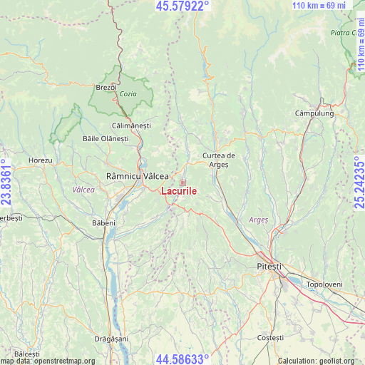
Lacurile GPS coordinates[2]
45° 5' 5.748" North, 24° 32' 21.192" East
| Map corner | latitude | longitude |
|---|---|---|
| Upper-left | 45.57922°, | 23.8361° |
| Center: | 45.08493°, | 24.53922° |
| Lower-right: | 44.58633°, | 25.24235° |
| Map W x H: | 110.4×110.4 km | = 68.6×68.6mi |
| max Lat: | 48.23793° ⇑66.1% North |
| Lacurile: | 45.08493° |
| min Lat: | ⇓33.9% South 43.65638° |
| min Long | Lacurile | max Long |
| 20.31667° | 24.53922° | 29.65403° |
| W 40.3%⇐ | ⇒59.7% E |
Elevation
Elevation of Lacurile is 358 m = 1175 ft, and this is 103.1 m = 338 ft above average elevation for this country.
| Max E: |
1278 m = 4193 ft | 24.4% |
| Lacurile | 358 m 1175 ft | |
| Avg. | 254.9 m = 836 ft | |
Min E: |
-2 m = -7 ft | 75.6% |
See also: Romania elevation on elevation.city.
Geographical zone
Lacurile is located in North temperate zone (between Tropic of Cancer and the Arctic Circle). Distance of this North polar circle is 2388.2 km =1484 mi to North.| Distance of | km | miles | from Lacurile |
|---|---|---|---|
| North Pole | 4994.1 | 3103.2 | to North |
| Arctic Circle | 2388.2 | 1484 | to North |
| Tropic Cancer | 2407.1 | 1495.7 | to South |
| Equator | 5013 | 3114.9 | to South |


Nearby cities:
15 places around Lacurile: (largest is in red/bold)
• Bârseștii de Jos
9.3 km =5.8 mi,  13°
13°
• Ciofrângeni
0.5 km =0.3 mi,  248°
248°
• Linia
10.7 km =6.6 mi,  262°
262°
• Milcoiu
6.9 km =4.3 mi,  235°
235°
• Morăreşti
7.9 km =4.9 mi,  164°
164°
• Noapteș
9.1 km =5.7 mi,  77°
77°
• Poienari
1.8 km =1.1 mi,  202°
202°
• Popești
5.1 km =3.2 mi,  282°
282°
• Racovița
11.1 km =6.9 mi,  266°
266°
• Runcu
11.5 km =7.1 mi,  322°
322°
• Tigveni
6.4 km =4 mi,  32°
32°
• Tutana
10 km =6.2 mi,  118°
118°
• Valea Brazilor
11.7 km =7.3 mi,  107°
107°
• Valea lui Enache
8.3 km =5.2 mi,  91°
91°
• Zigoneni
11.1 km =6.9 mi, 86°
Sources, notices
• [Note1] Compared only with cities in Romania existing in our database
• [Src1] Map data: © OpenStreetMap contributors (CC-BY-SA)
• [Src2] Other city data from geonames.org with taken over terms of usage.
• [Src3] Geographical zone / Annual Mean Temperature by Robert A. Rohde @ Wikipedia
