Jurilovca geodata
Jurilovca (Tulcea) is a seat of a second-order administrative division; located in Romania in Europe/Bucharest (GMT+3) time zone. With population of 5,133 people, there are 738 cities with bigger population in this country. Compared to other cities in Romania, 77.9% of cities are located further ↑North; 99.7% of cities are located further ←West and 92.7% of cities have higher elevation than Jurilovca. Note1


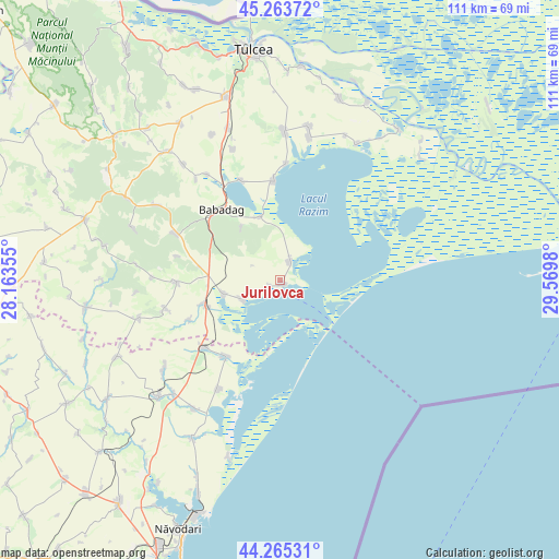
Jurilovca GPS coordinates[2]
44° 46' 0.012" North, 28° 52' 0.012" East
| Map corner | latitude | longitude |
|---|---|---|
| Upper-left | 45.26372°, | 28.16355° |
| Center: | 44.76667°, | 28.86667° |
| Lower-right: | 44.26531°, | 29.5698° |
| Map W x H: | 111×111 km | = 69×69mi |
| max Lat: | 48.23793° ⇑77.9% North |
| Jurilovca: | 44.76667° |
| min Lat: | ⇓22.1% South 43.65638° |
| min Long | Jurilovca | max Long |
| 20.31667° | 28.86667° | 29.65403° |
| W 99.7%⇐ | ⇒0.3% E |
Elevation
Elevation of Jurilovca is 45 m = 148 ft, and this is 209.9 m = 689 ft below average elevation for this country.
| Max E: |
1278 m = 4193 ft | 92.7% |
| Avg. | 254.9 m = 836 ft | |
| Jurilovca | 45 m = 148 ft | |
Min E: |
-2 m = -7 ft | 7.3% |
See also: Romania elevation on elevation.city.
Geographical zone
Jurilovca is located in North temperate zone (between Tropic of Cancer and the Arctic Circle). Distance of this Northern Tropic circle is 2371.7 km =1473.7 mi to South.| Distance of | km | miles | from Jurilovca |
|---|---|---|---|
| North Pole | 5029.5 | 3125.2 | to North |
| Arctic Circle | 2423.6 | 1506 | to North |
| Tropic Cancer | 2371.7 | 1473.7 | to South |
| Equator | 4977.6 | 3092.9 | to South |


Nearby cities:
15 places around Jurilovca: (largest is in red/bold)
• Babadag
19 km =11.8 mi,  321°
321°
• Baia
16.7 km =10.4 mi,  250°
250°
• Camena
21 km =13 mi,  283°
283°
• Ceamurlia de Jos
12.4 km =7.7 mi, 252°
• Ceamurlia de Sus
20.4 km =12.7 mi,  269°
269°
• Enisala
13.1 km =8.1 mi,  343°
343°
• Lunca
8.2 km =5.1 mi,  242°
242°
• Mihai Viteazu
20.7 km =12.9 mi,  224°
224°
• Sabangia
23.3 km =14.5 mi,  3°
3°
• Sarichioi
20.4 km =12.7 mi,  356°
356°
• Slava Rusă
22.6 km =14 mi,  294°
294°
• Sălcioara
1.3 km =0.8 mi,  90°
90°
• Visterna
12.8 km =8 mi, 323°
• Vișina
2.1 km =1.3 mi, 243°
• Zebil
21.4 km =13.3 mi, 338°
Sources, notices
• [Note1] Compared only with cities in Romania existing in our database
• [Src1] Map data: © OpenStreetMap contributors (CC-BY-SA)
• [Src2] Other city data from geonames.org with taken over terms of usage.
• [Src3] Geographical zone / Annual Mean Temperature by Robert A. Rohde @ Wikipedia
