Izvoarele geodata
Izvoarele (Alba) is a populated place; located in Romania in Europe/Bucharest (GMT+3) time zone. With population of 2,078 people, there are 2533 cities with bigger population in this country. Compared to other cities in Romania, 59% of cities are located further ↓South; 71% of cities are located further →East and 55.8% of cities have lower elevation than Izvoarele. Note1


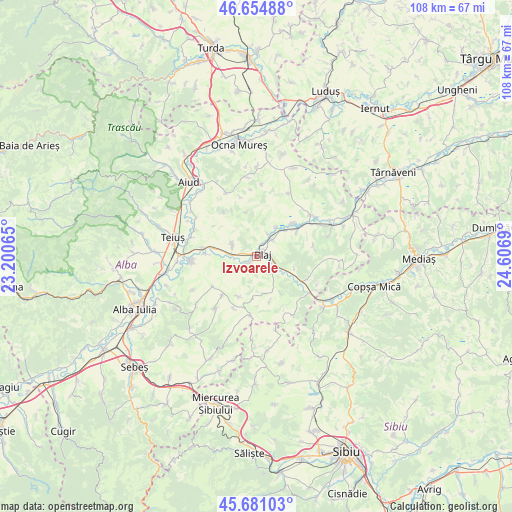
Izvoarele GPS coordinates[2]
46° 10' 12.396" North, 23° 54' 13.572" East
| Map corner | latitude | longitude |
|---|---|---|
| Upper-left | 46.65488°, | 23.20065° |
| Center: | 46.17011°, | 23.90377° |
| Lower-right: | 45.68103°, | 24.6069° |
| Map W x H: | 108.3×108.3 km | = 67.3×67.3mi |
| max Lat: | 48.23793° ⇑41% North |
| Izvoarele: | 46.17011° |
| min Lat: | ⇓59% South 43.65638° |
| min Long | Izvoarele | max Long |
| 20.31667° | 23.90377° | 29.65403° |
| W 29%⇐ | ⇒71% E |
Elevation
Elevation of Izvoarele is 242 m = 794 ft, and this is 12.9 m = 42 ft below average elevation for this country.
| Max E: |
1278 m = 4193 ft | 44.2% |
| Avg. | 254.9 m = 836 ft | |
| Izvoarele | 242 m = 794 ft | |
Min E: |
-2 m = -7 ft | 55.8% |
See also: Romania elevation on elevation.city.
Geographical zone
Izvoarele is located in North temperate zone (between Tropic of Cancer and the Arctic Circle). Distance of this North polar circle is 2267.5 km =1409 mi to North.| Distance of | km | miles | from Izvoarele |
|---|---|---|---|
| North Pole | 4873.4 | 3028.2 | to North |
| Arctic Circle | 2267.5 | 1409 | to North |
| Tropic Cancer | 2527.7 | 1570.6 | to South |
| Equator | 5133.6 | 3189.9 | to South |


Nearby cities:
15 places around Izvoarele: (largest is in red/bold)
• Beța
11.5 km =7.1 mi,  323°
323°
• Biia
10.3 km =6.4 mi,  48°
48°
• Blaj
1.1 km =0.7 mi,  59°
59°
• Bucerdea-Grânoasă
6.4 km =4 mi,  301°
301°
• Cergău Mare
8.1 km =5 mi,  169°
169°
• Cergău Mic
9.9 km =6.2 mi, 166°
• Cistei
11.7 km =7.3 mi,  279°
279°
• Crăciunelu de Jos
5.6 km =3.5 mi,  285°
285°
• Mănărade
5.9 km =3.7 mi,  122°
122°
• Obreja
10.7 km =6.6 mi,  272°
272°
• Pănade
7.4 km =4.6 mi,  34°
34°
• Sâncel
4.9 km =3 mi, 46°
• Tiur
1.6 km =1 mi,  225°
225°
• Veza
1.6 km =1 mi,  100°
100°
• Şona
10.1 km =6.3 mi, 59°
Sources, notices
• [Note1] Compared only with cities in Romania existing in our database
• [Src1] Map data: © OpenStreetMap contributors (CC-BY-SA)
• [Src2] Other city data from geonames.org with taken over terms of usage.
• [Src3] Geographical zone / Annual Mean Temperature by Robert A. Rohde @ Wikipedia
