Independenţa geodata
Independenţa (Galaţi) is a seat of a second-order administrative division; located in Romania in Europe/Bucharest (GMT+3) time zone. With population of 4,728 people, there are 873 cities with bigger population in this country. Compared to other cities in Romania, 55.7% of cities are located further ↑North; 93.7% of cities are located further ←West and 99.3% of cities have higher elevation than Independenţa. Note1


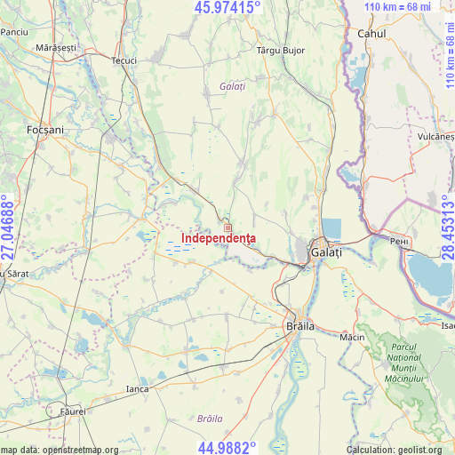
Independenţa GPS coordinates[2]
45° 28' 59.988" North, 27° 45' 0" East
| Map corner | latitude | longitude |
|---|---|---|
| Upper-left | 45.97415°, | 27.04688° |
| Center: | 45.48333°, | 27.75° |
| Lower-right: | 44.9882°, | 28.45313° |
| Map W x H: | 109.6×109.6 km | = 68.1×68.1mi |
| max Lat: | 48.23793° ⇑55.7% North |
| Independenţa: | 45.48333° |
| min Lat: | ⇓44.3% South 43.65638° |
| min Long | Independenţa | max Long |
| 20.31667° | 27.75° | 29.65403° |
| W 93.7%⇐ | ⇒6.3% E |
Elevation
Elevation of Independenţa is 9 m = 30 ft, and this is 245.9 m = 807 ft below average elevation for this country.
| Max E: |
1278 m = 4193 ft | 99.3% |
| Avg. | 254.9 m = 836 ft | |
| Independenţa | 9 m = 30 ft | |
Min E: |
-2 m = -7 ft | 0.7% |
See also: Romania elevation on elevation.city.
Geographical zone
Independenţa is located in North temperate zone (between Tropic of Cancer and the Arctic Circle). Distance of this North polar circle is 2343.9 km =1456.4 mi to North.| Distance of | km | miles | from Independenţa |
|---|---|---|---|
| North Pole | 4949.8 | 3075.7 | to North |
| Arctic Circle | 2343.9 | 1456.4 | to North |
| Tropic Cancer | 2451.4 | 1523.2 | to South |
| Equator | 5057.3 | 3142.5 | to South |


Nearby cities:
15 places around Independenţa: (largest is in red/bold)
• Braniştea
8.6 km =5.3 mi,  115°
115°
• Cuza Vodă
13 km =8.1 mi,  14°
14°
• Izvoarele
7.1 km =4.4 mi, 12°
• Latinu
11 km =6.8 mi,  201°
201°
• Mihail Kogălniceanu
14.3 km =8.9 mi,  81°
81°
• Măxineni
13 km =8.1 mi,  224°
224°
• Negrea
11.1 km =6.9 mi,  58°
58°
• Nămoloasa-Sat
14.1 km =8.8 mi,  293°
293°
• Piscu
2.3 km =1.4 mi,  324°
324°
• Schela
5.5 km =3.4 mi,  70°
70°
• Slobozia Conachi
11.4 km =7.1 mi, 13°
• Smârdan
14.3 km =8.9 mi,  90°
90°
• Tudor Vladimirescu
12.1 km =7.5 mi, 319°
• Vasile Alecsandri
5.2 km =3.2 mi,  130°
130°
• Șerbeștii Vechi
12.2 km =7.6 mi, 124°
Sources, notices
• [Note1] Compared only with cities in Romania existing in our database
• [Src1] Map data: © OpenStreetMap contributors (CC-BY-SA)
• [Src2] Other city data from geonames.org with taken over terms of usage.
• [Src3] Geographical zone / Annual Mean Temperature by Robert A. Rohde @ Wikipedia
