Iezureni geodata
Iezureni (Gorj) is a populated place; located in Romania in Europe/Bucharest (GMT+3) time zone. With population of 548 people, there are 6601 cities with bigger population in this country. Compared to other cities in Romania, 65.9% of cities are located further ↑North; 79.6% of cities are located further →East and 54.4% of cities have lower elevation than Iezureni. Note1


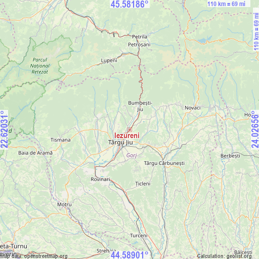
Iezureni GPS coordinates[2]
45° 5' 15.324" North, 23° 19' 24.348" East
| Map corner | latitude | longitude |
|---|---|---|
| Upper-left | 45.58186°, | 22.62031° |
| Center: | 45.08759°, | 23.32343° |
| Lower-right: | 44.58901°, | 24.02656° |
| Map W x H: | 110.4×110.4 km | = 68.6×68.6mi |
| max Lat: | 48.23793° ⇑65.9% North |
| Iezureni: | 45.08759° |
| min Lat: | ⇓34.1% South 43.65638° |
| min Long | Iezureni | max Long |
| 20.31667° | 23.32343° | 29.65403° |
| W 20.4%⇐ | ⇒79.6% E |
Elevation
Elevation of Iezureni is 235 m = 771 ft, and this is 19.9 m = 65 ft below average elevation for this country.
| Max E: |
1278 m = 4193 ft | 45.6% |
| Avg. | 254.9 m = 836 ft | |
| Iezureni | 235 m = 771 ft | |
Min E: |
-2 m = -7 ft | 54.4% |
See also: Romania elevation on elevation.city.
Geographical zone
Iezureni is located in North temperate zone (between Tropic of Cancer and the Arctic Circle). Distance of this North polar circle is 2387.9 km =1483.8 mi to North.| Distance of | km | miles | from Iezureni |
|---|---|---|---|
| North Pole | 4993.8 | 3103 | to North |
| Arctic Circle | 2387.9 | 1483.8 | to North |
| Tropic Cancer | 2407.4 | 1495.9 | to South |
| Equator | 5013.3 | 3115.1 | to South |


Nearby cities:
15 places around Iezureni: (largest is in red/bold)
• Bârsești
8.2 km =5.1 mi,  239°
239°
• Bălăneşti
6.4 km =4 mi,  111°
111°
• Cartiu
3.9 km =2.4 mi,  352°
352°
• Curpen
9.2 km =5.7 mi,  326°
326°
• Curtișoara
3.5 km =2.2 mi,  57°
57°
• Drăgoieni
5.1 km =3.2 mi,  168°
168°
• Pișteștii din Deal
8.6 km =5.3 mi,  136°
136°
• Preajba Mare
3.4 km =2.1 mi, 142°
• Rugi
6 km =3.7 mi, 334°
• Stăneşti
6.6 km =4.1 mi,  299°
299°
• Sâmbotin
5.1 km =3.2 mi,  8°
8°
• Tetila
6.3 km =3.9 mi,  51°
51°
• Turcineşti
1.6 km =1 mi,  29°
29°
• Târgu Jiu
5.2 km =3.2 mi,  216°
216°
• Voiteștii din Vale
7.7 km =4.8 mi,  90°
90°
Sources, notices
• [Note1] Compared only with cities in Romania existing in our database
• [Src1] Map data: © OpenStreetMap contributors (CC-BY-SA)
• [Src2] Other city data from geonames.org with taken over terms of usage.
• [Src3] Geographical zone / Annual Mean Temperature by Robert A. Rohde @ Wikipedia
