Stăneşti geodata
Stăneşti (Gorj) is a seat of a second-order administrative division; located in Romania in Europe/Bucharest (GMT+3) time zone. With population of 2,647 people, there are 2020 cities with bigger population in this country. Compared to other cities in Romania, 64.9% of cities are located further ↑North; 80.9% of cities are located further →East and 66.1% of cities have lower elevation than Stăneşti. Note1


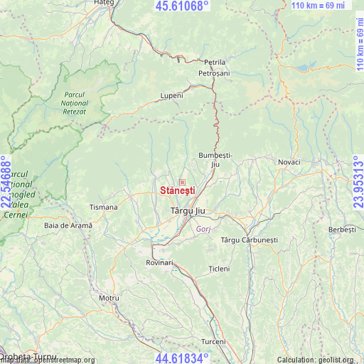
Stăneşti GPS coordinates[2]
45° 7' 0.012" North, 23° 15' 0" East
| Map corner | latitude | longitude |
|---|---|---|
| Upper-left | 45.61068°, | 22.54688° |
| Center: | 45.11667°, | 23.25° |
| Lower-right: | 44.61834°, | 23.95313° |
| Map W x H: | 110.3×110.3 km | = 68.5×68.5mi |
| max Lat: | 48.23793° ⇑64.9% North |
| Stăneşti: | 45.11667° |
| min Lat: | ⇓35.1% South 43.65638° |
| min Long | Stăneşti | max Long |
| 20.31667° | 23.25° | 29.65403° |
| W 19.1%⇐ | ⇒80.9% E |
Elevation
Elevation of Stăneşti is 297 m = 974 ft, and this is 42.1 m = 138 ft above average elevation for this country.
| Max E: |
1278 m = 4193 ft | 33.9% |
| Stăneşti | 297 m 974 ft | |
| Avg. | 254.9 m = 836 ft | |
Min E: |
-2 m = -7 ft | 66.1% |
See also: Romania elevation on elevation.city.
Geographical zone
Stăneşti is located in North temperate zone (between Tropic of Cancer and the Arctic Circle). Distance of this North polar circle is 2384.7 km =1481.8 mi to North.| Distance of | km | miles | from Stăneşti |
|---|---|---|---|
| North Pole | 4990.6 | 3101 | to North |
| Arctic Circle | 2384.7 | 1481.8 | to North |
| Tropic Cancer | 2410.6 | 1497.9 | to South |
| Equator | 5016.5 | 3117.1 | to South |


Nearby cities:
15 places around Stăneşti: (largest is in red/bold)
• Bârsești
7.5 km =4.7 mi,  190°
190°
• Cartiu
5.3 km =3.3 mi,  83°
83°
• Curpen
4.6 km =2.9 mi,  8°
8°
• Curtișoara
8.8 km =5.5 mi,  99°
99°
• Dobrița
6.3 km =3.9 mi,  288°
288°
• Iezureni
6.6 km =4.1 mi,  119°
119°
• Leleşti
4.3 km =2.7 mi,  244°
244°
• Preajba Mare
9.8 km =6.1 mi,  126°
126°
• Rasova
9.3 km =5.8 mi,  214°
214°
• Rugi
3.9 km =2.4 mi,  55°
55°
• Runcu
9.2 km =5.7 mi,  270°
270°
• Slobozia
9.8 km =6.1 mi, 188°
• Sâmbotin
6.8 km =4.2 mi,  74°
74°
• Turcineşti
6.8 km =4.2 mi,  105°
105°
• Târgu Jiu
7.9 km =4.9 mi,  160°
160°
Sources, notices
• [Note1] Compared only with cities in Romania existing in our database
• [Src1] Map data: © OpenStreetMap contributors (CC-BY-SA)
• [Src2] Other city data from geonames.org with taken over terms of usage.
• [Src3] Geographical zone / Annual Mean Temperature by Robert A. Rohde @ Wikipedia
