Hotărani geodata
Hotărani (Olt) is a populated place; located in Romania in Europe/Bucharest (GMT+3) time zone. With population of 974 people, there are 4368 cities with bigger population in this country. Compared to other cities in Romania, 94.3% of cities are located further ↑North; 61.5% of cities are located further →East and 81.6% of cities have higher elevation than Hotărani. Note1


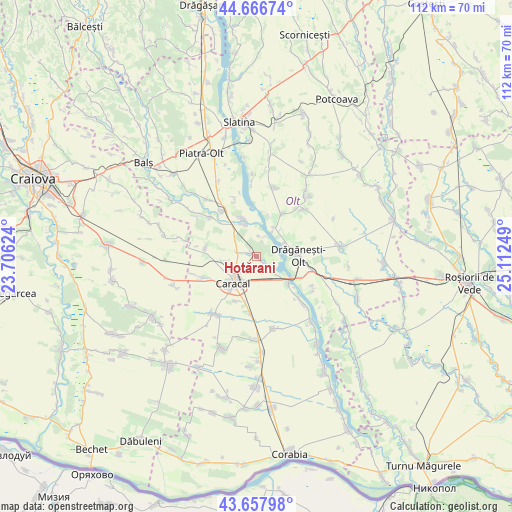
Hotărani GPS coordinates[2]
44° 9' 52.272" North, 24° 24' 33.696" East
| Map corner | latitude | longitude |
|---|---|---|
| Upper-left | 44.66674°, | 23.70624° |
| Center: | 44.16452°, | 24.40936° |
| Lower-right: | 43.65798°, | 25.11249° |
| Map W x H: | 112.2×112.2 km | = 69.7×69.7mi |
| max Lat: | 48.23793° ⇑94.3% North |
| Hotărani: | 44.16452° |
| min Lat: | ⇓5.7% South 43.65638° |
| min Long | Hotărani | max Long |
| 20.31667° | 24.40936° | 29.65403° |
| W 38.5%⇐ | ⇒61.5% E |
Elevation
Elevation of Hotărani is 89 m = 292 ft, and this is 165.9 m = 544 ft below average elevation for this country.
| Max E: |
1278 m = 4193 ft | 81.6% |
| Avg. | 254.9 m = 836 ft | |
| Hotărani | 89 m = 292 ft | |
Min E: |
-2 m = -7 ft | 18.4% |
See also: Romania elevation on elevation.city.
Geographical zone
Hotărani is located in North temperate zone (between Tropic of Cancer and the Arctic Circle). Distance of this Northern Tropic circle is 2304.7 km =1432.1 mi to South.| Distance of | km | miles | from Hotărani |
|---|---|---|---|
| North Pole | 5096.4 | 3166.8 | to North |
| Arctic Circle | 2490.5 | 1547.5 | to North |
| Tropic Cancer | 2304.7 | 1432.1 | to South |
| Equator | 4910.6 | 3051.3 | to South |


Nearby cities:
15 places around Hotărani: (largest is in red/bold)
• Caracal
7.1 km =4.4 mi,  221°
221°
• Cioroiașu
9.3 km =5.8 mi,  339°
339°
• Cioroiu
8.6 km =5.3 mi, 344°
• Comanca
10.4 km =6.5 mi,  202°
202°
• Comani
6.9 km =4.3 mi,  72°
72°
• Dobrosloveni
4 km =2.5 mi,  301°
301°
• Drăgăneşti-Olt
9.9 km =6.2 mi,  88°
88°
• Fălcoiu
8.4 km =5.2 mi, 336°
• Fărcaşele
2.5 km =1.6 mi,  130°
130°
• Fărcașu de Jos
5.1 km =3.2 mi, 129°
• Ghimpați
1.9 km =1.2 mi, 130°
• Mărunţei
6 km =3.7 mi,  49°
49°
• Potopinu
5.5 km =3.4 mi,  306°
306°
• Reșca
1.6 km =1 mi, 303°
• Stoeneşti
9 km =5.6 mi, 126°
Sources, notices
• [Note1] Compared only with cities in Romania existing in our database
• [Src1] Map data: © OpenStreetMap contributors (CC-BY-SA)
• [Src2] Other city data from geonames.org with taken over terms of usage.
• [Src3] Geographical zone / Annual Mean Temperature by Robert A. Rohde @ Wikipedia
