Cioroiașu geodata
Cioroiașu (Olt) is a populated place; located in Romania in Europe/Bucharest (GMT+3) time zone. With population of 636 people, there are 5970 cities with bigger population in this country. Compared to other cities in Romania, 92.3% of cities are located further ↑North; 62.3% of cities are located further →East and 82.2% of cities have higher elevation than Cioroiașu. Note1


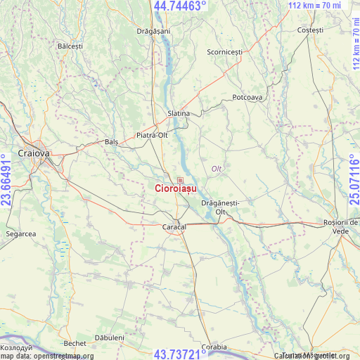
Cioroiașu GPS coordinates[2]
44° 14' 35.088" North, 24° 22' 4.908" East
| Map corner | latitude | longitude |
|---|---|---|
| Upper-left | 44.74463°, | 23.66491° |
| Center: | 44.24308°, | 24.36803° |
| Lower-right: | 43.73721°, | 25.07116° |
| Map W x H: | 112×112 km | = 69.6×69.6mi |
| max Lat: | 48.23793° ⇑92.3% North |
| Cioroiașu: | 44.24308° |
| min Lat: | ⇓7.7% South 43.65638° |
| min Long | Cioroiașu | max Long |
| 20.31667° | 24.36803° | 29.65403° |
| W 37.7%⇐ | ⇒62.3% E |
Elevation
Elevation of Cioroiașu is 87 m = 285 ft, and this is 167.9 m = 551 ft below average elevation for this country.
| Max E: |
1278 m = 4193 ft | 82.2% |
| Avg. | 254.9 m = 836 ft | |
| Cioroiașu | 87 m = 285 ft | |
Min E: |
-2 m = -7 ft | 17.8% |
See also: Romania elevation on elevation.city.
Geographical zone
Cioroiașu is located in North temperate zone (between Tropic of Cancer and the Arctic Circle). Distance of this Northern Tropic circle is 2313.5 km =1437.5 mi to South.| Distance of | km | miles | from Cioroiașu |
|---|---|---|---|
| North Pole | 5087.7 | 3161.3 | to North |
| Arctic Circle | 2481.8 | 1542.1 | to North |
| Tropic Cancer | 2313.5 | 1437.5 | to South |
| Equator | 4919.4 | 3056.8 | to South |


Nearby cities:
15 places around Cioroiașu: (largest is in red/bold)
• Bălănești
9.1 km =5.7 mi,  85°
85°
• Cioroiu
1.1 km =0.7 mi,  113°
113°
• Dobrosloveni
6.6 km =4.1 mi,  180°
180°
• Fălcoiu
1.1 km =0.7 mi,  185°
185°
• Greci
4.4 km =2.7 mi,  343°
343°
• Hotărani
9.3 km =5.8 mi,  159°
159°
• Mărunţei
9.2 km =5.7 mi,  121°
121°
• Ociogi
8.7 km =5.4 mi,  350°
350°
• Osica de Jos
7.1 km =4.4 mi,  271°
271°
• Osica de Sus
4.2 km =2.6 mi,  280°
280°
• Potopinu
5.6 km =3.5 mi, 192°
• Reșca
8.1 km =5 mi,  166°
166°
• Vlăduleni
3.6 km =2.2 mi,  295°
295°
• Văleni
7.7 km =4.8 mi,  319°
319°
• Şopârliţa
8.1 km =5 mi, 303°
Sources, notices
• [Note1] Compared only with cities in Romania existing in our database
• [Src1] Map data: © OpenStreetMap contributors (CC-BY-SA)
• [Src2] Other city data from geonames.org with taken over terms of usage.
• [Src3] Geographical zone / Annual Mean Temperature by Robert A. Rohde @ Wikipedia
