Hoisești geodata
Hoisești (Neamţ) is a populated place; located in Romania in Europe/Bucharest (GMT+3) time zone. With population of 985 people, there are 4340 cities with bigger population in this country. Compared to other cities in Romania, 76% of cities are located further ↓South; 75.9% of cities are located further ←West and 69.6% of cities have lower elevation than Hoisești. Note1


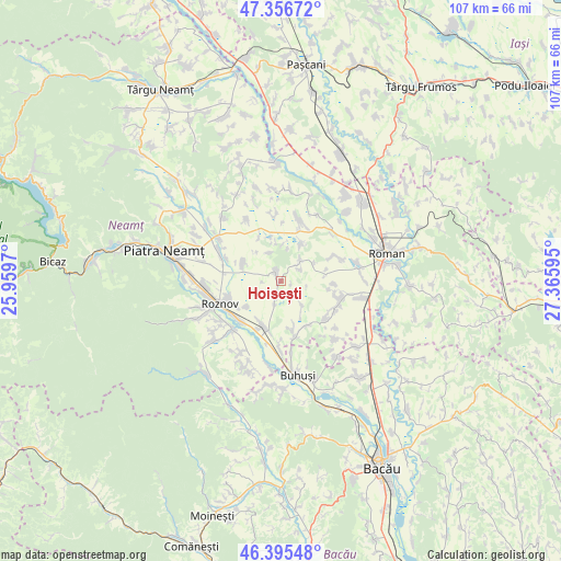
Hoisești GPS coordinates[2]
46° 52' 41.7" North, 26° 39' 46.152" East
| Map corner | latitude | longitude |
|---|---|---|
| Upper-left | 47.35672°, | 25.9597° |
| Center: | 46.87825°, | 26.66282° |
| Lower-right: | 46.39548°, | 27.36595° |
| Map W x H: | 106.9×106.9 km | = 66.4×66.4mi |
| max Lat: | 48.23793° ⇑24% North |
| Hoisești: | 46.87825° |
| min Lat: | ⇓76% South 43.65638° |
| min Long | Hoisești | max Long |
| 20.31667° | 26.66282° | 29.65403° |
| W 75.9%⇐ | ⇒24.1% E |
Elevation
Elevation of Hoisești is 317 m = 1040 ft, and this is 62.1 m = 204 ft above average elevation for this country.
| Max E: |
1278 m = 4193 ft | 30.4% |
| Hoisești | 317 m 1040 ft | |
| Avg. | 254.9 m = 836 ft | |
Min E: |
-2 m = -7 ft | 69.6% |
See also: Romania elevation on elevation.city.
Geographical zone
Hoisești is located in North temperate zone (between Tropic of Cancer and the Arctic Circle). Distance of this North polar circle is 2188.8 km =1360.1 mi to North.| Distance of | km | miles | from Hoisești |
|---|---|---|---|
| North Pole | 4794.7 | 2979.3 | to North |
| Arctic Circle | 2188.8 | 1360.1 | to North |
| Tropic Cancer | 2606.5 | 1619.6 | to South |
| Equator | 5212.4 | 3238.8 | to South |


Nearby cities:
15 places around Hoisești: (largest is in red/bold)
• Budești
7.9 km =4.9 mi,  28°
28°
• Butnărești
9.9 km =6.2 mi,  93°
93°
• Bălănești
8 km =5 mi,  346°
346°
• Dochia
7.9 km =4.9 mi,  294°
294°
• Făurei
4.5 km =2.8 mi,  20°
20°
• Goșmani
6.1 km =3.8 mi,  139°
139°
• Hociungi
11.2 km =7 mi,  130°
130°
• Moldoveni
9.3 km =5.8 mi,  122°
122°
• Mărgineni
3.3 km =2.1 mi,  317°
317°
• Podoleni
9.4 km =5.8 mi,  201°
201°
• Români
10.7 km =6.6 mi,  171°
171°
• Siliștea
11.4 km =7.1 mi, 168°
• Slobozia
10.4 km =6.5 mi,  251°
251°
• Traian
8.2 km =5.1 mi,  232°
232°
• Zăneşti
11 km =6.8 mi, 231°
Sources, notices
• [Note1] Compared only with cities in Romania existing in our database
• [Src1] Map data: © OpenStreetMap contributors (CC-BY-SA)
• [Src2] Other city data from geonames.org with taken over terms of usage.
• [Src3] Geographical zone / Annual Mean Temperature by Robert A. Rohde @ Wikipedia
