Făurei geodata
Făurei (Neamţ) is a seat of a second-order administrative division; located in Romania in Europe/Bucharest (GMT+3) time zone. With population of 2,344 people, there are 2271 cities with bigger population in this country. Compared to other cities in Romania, 76.7% of cities are located further ↓South; 76.2% of cities are located further ←West and 83.3% of cities have lower elevation than Făurei. Note1


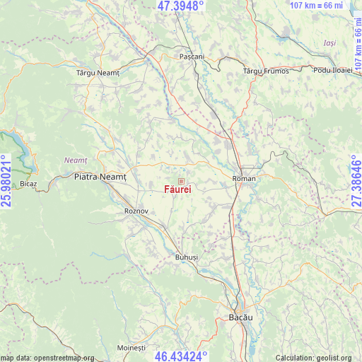
Făurei GPS coordinates[2]
46° 55' 0.012" North, 26° 40' 59.988" East
| Map corner | latitude | longitude |
|---|---|---|
| Upper-left | 47.3948°, | 25.98021° |
| Center: | 46.91667°, | 26.68333° |
| Lower-right: | 46.43424°, | 27.38646° |
| Map W x H: | 106.8×106.8 km | = 66.4×66.4mi |
| max Lat: | 48.23793° ⇑23.3% North |
| Făurei: | 46.91667° |
| min Lat: | ⇓76.7% South 43.65638° |
| min Long | Făurei | max Long |
| 20.31667° | 26.68333° | 29.65403° |
| W 76.2%⇐ | ⇒23.8% E |
Elevation
Elevation of Făurei is 426 m = 1398 ft, and this is 171.1 m = 561 ft above average elevation for this country.
| Max E: |
1278 m = 4193 ft | 16.7% |
| Făurei | 426 m 1398 ft | |
| Avg. | 254.9 m = 836 ft | |
Min E: |
-2 m = -7 ft | 83.3% |
See also: Romania elevation on elevation.city.
Geographical zone
Făurei is located in North temperate zone (between Tropic of Cancer and the Arctic Circle). Distance of this North polar circle is 2184.5 km =1357.4 mi to North.| Distance of | km | miles | from Făurei |
|---|---|---|---|
| North Pole | 4790.4 | 2976.6 | to North |
| Arctic Circle | 2184.5 | 1357.4 | to North |
| Tropic Cancer | 2610.7 | 1622.2 | to South |
| Equator | 5216.6 | 3241.4 | to South |


Nearby cities:
15 places around Făurei: (largest is in red/bold)
• Budești
3.4 km =2.1 mi,  38°
38°
• Butnărești
9.7 km =6 mi,  120°
120°
• Bârgăuani
8.3 km =5.2 mi,  332°
332°
• Bălănești
5 km =3.1 mi,  315°
315°
• Corhana
11.9 km =7.4 mi,  53°
53°
• Dochia
8.8 km =5.5 mi,  263°
263°
• Dulceşti
8.4 km =5.2 mi, 48°
• Ghigoiești
10.9 km =6.8 mi,  312°
312°
• Goșmani
9.3 km =5.8 mi,  164°
164°
• Hoisești
4.5 km =2.8 mi,  200°
200°
• Miron Costin
9.3 km =5.8 mi,  87°
87°
• Moldoveni
11.2 km =7 mi,  145°
145°
• Mărgineni
4.2 km =2.6 mi,  243°
243°
• Ruginoasa
7.9 km =4.9 mi,  12°
12°
• Trifeşti
10.1 km =6.3 mi, 90°
Sources, notices
• [Note1] Compared only with cities in Romania existing in our database
• [Src1] Map data: © OpenStreetMap contributors (CC-BY-SA)
• [Src2] Other city data from geonames.org with taken over terms of usage.
• [Src3] Geographical zone / Annual Mean Temperature by Robert A. Rohde @ Wikipedia
