Hârlești geodata
Hârlești (Bacău) is a populated place; located in Romania in Europe/Bucharest (GMT+3) time zone. With population of 729 people, there are 5409 cities with bigger population in this country. Compared to other cities in Romania, 74.5% of cities are located further ↓South; 80.6% of cities are located further ←West and 58.7% of cities have higher elevation than Hârlești. Note1


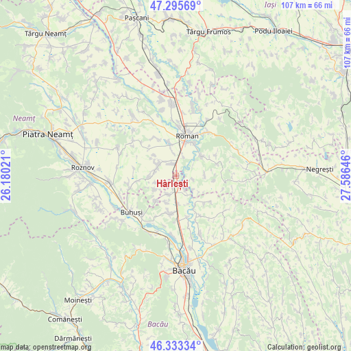
Hârlești GPS coordinates[2]
46° 49' 0.012" North, 26° 52' 59.988" East
| Map corner | latitude | longitude |
|---|---|---|
| Upper-left | 47.29569°, | 26.18021° |
| Center: | 46.81667°, | 26.88333° |
| Lower-right: | 46.33334°, | 27.58646° |
| Map W x H: | 107×107 km | = 66.5×66.5mi |
| max Lat: | 48.23793° ⇑25.5% North |
| Hârlești: | 46.81667° |
| min Lat: | ⇓74.5% South 43.65638° |
| min Long | Hârlești | max Long |
| 20.31667° | 26.88333° | 29.65403° |
| W 80.6%⇐ | ⇒19.4% E |
Elevation
Elevation of Hârlești is 171 m = 561 ft, and this is 83.9 m = 275 ft below average elevation for this country.
| Max E: |
1278 m = 4193 ft | 58.7% |
| Avg. | 254.9 m = 836 ft | |
| Hârlești | 171 m = 561 ft | |
Min E: |
-2 m = -7 ft | 41.3% |
See also: Romania elevation on elevation.city.
Geographical zone
Hârlești is located in North temperate zone (between Tropic of Cancer and the Arctic Circle). Distance of this North polar circle is 2195.6 km =1364.3 mi to North.| Distance of | km | miles | from Hârlești |
|---|---|---|---|
| North Pole | 4801.5 | 2983.5 | to North |
| Arctic Circle | 2195.6 | 1364.3 | to North |
| Tropic Cancer | 2599.6 | 1615.3 | to South |
| Equator | 5205.5 | 3234.5 | to South |


Nearby cities:
15 places around Hârlești: (largest is in red/bold)
• Bahna
8.5 km =5.3 mi,  244°
244°
• Bașta
5.9 km =3.7 mi,  22°
22°
• Butnărești
9.3 km =5.8 mi,  312°
312°
• Bălușești
8.8 km =5.5 mi,  90°
90°
• Cârligi
6.2 km =3.9 mi,  203°
203°
• Filipeşti
7.4 km =4.6 mi,  180°
180°
• Galbeni
8.8 km =5.5 mi, 200°
• Hociungi
8.2 km =5.1 mi,  267°
267°
• Horia
10.4 km =6.5 mi, 15°
• Icuseşti
4.2 km =2.6 mi,  115°
115°
• Ion Creangă
9.5 km =5.9 mi,  51°
51°
• Izvoare
9.9 km =6.2 mi,  218°
218°
• Moldoveni
9.1 km =5.7 mi,  281°
281°
• Recea
6.6 km =4.1 mi,  55°
55°
• Secuieni
5.3 km =3.3 mi, 314°
Sources, notices
• [Note1] Compared only with cities in Romania existing in our database
• [Src1] Map data: © OpenStreetMap contributors (CC-BY-SA)
• [Src2] Other city data from geonames.org with taken over terms of usage.
• [Src3] Geographical zone / Annual Mean Temperature by Robert A. Rohde @ Wikipedia
