Icuseşti geodata
Icuseşti (Neamţ) is a seat of a second-order administrative division; located in Romania in Europe/Bucharest (GMT+3) time zone. With population of 4,648 people, there are 902 cities with bigger population in this country. Compared to other cities in Romania, 74.1% of cities are located further ↓South; 81.8% of cities are located further ←West and 59.2% of cities have higher elevation than Icuseşti. Note1


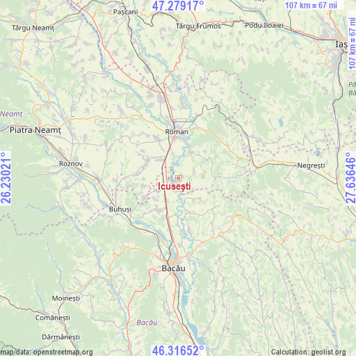
Icuseşti GPS coordinates[2]
46° 48' 0" North, 26° 55' 59.988" East
| Map corner | latitude | longitude |
|---|---|---|
| Upper-left | 47.27917°, | 26.23021° |
| Center: | 46.8°, | 26.93333° |
| Lower-right: | 46.31652°, | 27.63646° |
| Map W x H: | 107×107 km | = 66.5×66.5mi |
| max Lat: | 48.23793° ⇑25.9% North |
| Icuseşti: | 46.8° |
| min Lat: | ⇓74.1% South 43.65638° |
| min Long | Icuseşti | max Long |
| 20.31667° | 26.93333° | 29.65403° |
| W 81.8%⇐ | ⇒18.2% E |
Elevation
Elevation of Icuseşti is 169 m = 554 ft, and this is 85.9 m = 282 ft below average elevation for this country.
| Max E: |
1278 m = 4193 ft | 59.2% |
| Avg. | 254.9 m = 836 ft | |
| Icuseşti | 169 m = 554 ft | |
Min E: |
-2 m = -7 ft | 40.8% |
See also: Romania elevation on elevation.city.
Geographical zone
Icuseşti is located in North temperate zone (between Tropic of Cancer and the Arctic Circle). Distance of this North polar circle is 2197.5 km =1365.5 mi to North.| Distance of | km | miles | from Icuseşti |
|---|---|---|---|
| North Pole | 4803.4 | 2984.7 | to North |
| Arctic Circle | 2197.5 | 1365.5 | to North |
| Tropic Cancer | 2597.8 | 1614.2 | to South |
| Equator | 5203.7 | 3233.4 | to South |


Nearby cities:
15 places around Icuseşti: (largest is in red/bold)
• Bașta
7.4 km =4.6 mi,  348°
348°
• Bucium
10.8 km =6.7 mi,  102°
102°
• Bălușești
5.3 km =3.3 mi,  70°
70°
• Chilii
7.7 km =4.8 mi,  87°
87°
• Cârligi
7.4 km =4.6 mi,  238°
238°
• Călugăreni
9.2 km =5.7 mi,  132°
132°
• Dămieneşti
8.3 km =5.2 mi,  152°
152°
• Filipeşti
6.7 km =4.2 mi,  214°
214°
• Galbeni
9.4 km =5.8 mi,  227°
227°
• Hârlești
4.2 km =2.6 mi,  295°
295°
• Ion Creangă
8.6 km =5.3 mi,  24°
24°
• Negri
11.4 km =7.1 mi,  167°
167°
• Recea
5.8 km =3.6 mi, 16°
• Secuieni
9.4 km =5.8 mi,  306°
306°
• Stejaru
10.4 km =6.5 mi,  59°
59°
Sources, notices
• [Note1] Compared only with cities in Romania existing in our database
• [Src1] Map data: © OpenStreetMap contributors (CC-BY-SA)
• [Src2] Other city data from geonames.org with taken over terms of usage.
• [Src3] Geographical zone / Annual Mean Temperature by Robert A. Rohde @ Wikipedia
