Herendești geodata
Herendești (Timiş) is a populated place; located in Romania in Europe/Bucharest (GMT+3) time zone. With population of 551 people, there are 6574 cities with bigger population in this country. Compared to other cities in Romania, 52.8% of cities are located further ↑North; 95.3% of cities are located further →East and 69.6% of cities have higher elevation than Herendești. Note1


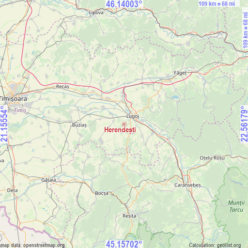
Herendești GPS coordinates[2]
45° 39' 2.448" North, 21° 51' 31.176" East
| Map corner | latitude | longitude |
|---|---|---|
| Upper-left | 46.14003°, | 21.15554° |
| Center: | 45.65068°, | 21.85866° |
| Lower-right: | 45.15702°, | 22.56179° |
| Map W x H: | 109.3×109.3 km | = 67.9×67.9mi |
| max Lat: | 48.23793° ⇑52.8% North |
| Herendești: | 45.65068° |
| min Lat: | ⇓47.2% South 43.65638° |
| min Long | Herendești | max Long |
| 20.31667° | 21.85866° | 29.65403° |
| W 4.7%⇐ | ⇒95.3% E |
Elevation
Elevation of Herendești is 129 m = 423 ft, and this is 125.9 m = 413 ft below average elevation for this country.
| Max E: |
1278 m = 4193 ft | 69.6% |
| Avg. | 254.9 m = 836 ft | |
| Herendești | 129 m = 423 ft | |
Min E: |
-2 m = -7 ft | 30.4% |
See also: Romania elevation on elevation.city.
Geographical zone
Herendești is located in North temperate zone (between Tropic of Cancer and the Arctic Circle). Distance of this North polar circle is 2325.3 km =1444.9 mi to North.| Distance of | km | miles | from Herendești |
|---|---|---|---|
| North Pole | 4931.2 | 3064.1 | to North |
| Arctic Circle | 2325.3 | 1444.9 | to North |
| Tropic Cancer | 2470 | 1534.8 | to South |
| Equator | 5075.9 | 3154 | to South |


Nearby cities:
15 places around Herendești: (largest is in red/bold)
• Boldur
8 km =5 mi,  307°
307°
• Coşteiu
10.1 km =6.3 mi,  355°
355°
• Darova
6.7 km =4.2 mi,  261°
261°
• Darova Nouă
7.4 km =4.6 mi,  254°
254°
• Gavojdia
12.9 km =8 mi,  107°
107°
• Lugoj
5.4 km =3.4 mi,  39°
39°
• Lugojel
8.2 km =5.1 mi,  77°
77°
• Măguri
11.1 km =6.9 mi, 82°
• Ohaba-Forgaci
11.9 km =7.4 mi, 309°
• Petroasa Mare
3.8 km =2.4 mi,  195°
195°
• Sacoșu Mare
12.4 km =7.7 mi,  233°
233°
• Sinersig
10.9 km =6.8 mi,  283°
283°
• Victor Vlad Delamarina
2.9 km =1.8 mi, 112°
• Vișag
11.8 km =7.3 mi, 197°
• Ştiuca
12.7 km =7.9 mi,  133°
133°
Sources, notices
• [Note1] Compared only with cities in Romania existing in our database
• [Src1] Map data: © OpenStreetMap contributors (CC-BY-SA)
• [Src2] Other city data from geonames.org with taken over terms of usage.
• [Src3] Geographical zone / Annual Mean Temperature by Robert A. Rohde @ Wikipedia
