Lugoj geodata
Lugoj (Timiş) is a seat of a second-order administrative division; located in Romania in Europe/Bucharest (GMT+3) time zone. With population of 43,243 people, there are 53 cities with bigger population in this country. Compared to other cities in Romania, 52.2% of cities are located further ↑North; 95.1% of cities are located further →East and 71.4% of cities have higher elevation than Lugoj. Note1


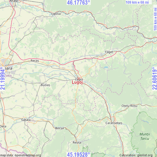
Lugoj GPS coordinates[2]
45° 41' 18.996" North, 21° 54' 11.016" East
| Map corner | latitude | longitude |
|---|---|---|
| Upper-left | 46.17763°, | 21.19994° |
| Center: | 45.68861°, | 21.90306° |
| Lower-right: | 45.19528°, | 22.60619° |
| Map W x H: | 109.2×109.2 km | = 67.9×67.9mi |
| max Lat: | 48.23793° ⇑52.2% North |
| Lugoj: | 45.68861° |
| min Lat: | ⇓47.8% South 43.65638° |
| min Long | Lugoj | max Long |
| 20.31667° | 21.90306° | 29.65403° |
| W 4.9%⇐ | ⇒95.1% E |
Elevation
Elevation of Lugoj is 122 m = 400 ft, and this is 132.9 m = 436 ft below average elevation for this country.
| Max E: |
1278 m = 4193 ft | 71.4% |
| Avg. | 254.9 m = 836 ft | |
| Lugoj | 122 m = 400 ft | |
Min E: |
-2 m = -7 ft | 28.6% |
See also: Lugoj elevation on elevation.city.
Geographical zone
Lugoj is located in North temperate zone (between Tropic of Cancer and the Arctic Circle). Distance of this North polar circle is 2321.1 km =1442.3 mi to North.| Distance of | km | miles | from Lugoj |
|---|---|---|---|
| North Pole | 4927 | 3061.5 | to North |
| Arctic Circle | 2321.1 | 1442.3 | to North |
| Tropic Cancer | 2474.2 | 1537.4 | to South |
| Equator | 5080.1 | 3156.6 | to South |


Nearby cities:
15 places around Lugoj: (largest is in red/bold)
• Belinţ
13.3 km =8.3 mi,  303°
303°
• Boldur
9.8 km =6.1 mi,  273°
273°
• Bârna
11.8 km =7.3 mi,  74°
74°
• Coşteiu
7.2 km =4.5 mi,  324°
324°
• Criciova
14.1 km =8.8 mi,  115°
115°
• Darova
11.3 km =7 mi,  242°
242°
• Darova Nouă
12.3 km =7.6 mi, 239°
• Gavojdia
11.9 km =7.4 mi,  132°
132°
• Herendești
5.4 km =3.4 mi,  219°
219°
• Lugojel
5.2 km =3.2 mi, 118°
• Măguri
8 km =5 mi,  110°
110°
• Ohaba-Forgaci
13 km =8.1 mi,  284°
284°
• Petroasa Mare
9.1 km =5.7 mi,  209°
209°
• Sinersig
14.1 km =8.8 mi,  263°
263°
• Victor Vlad Delamarina
5.4 km =3.4 mi,  188°
188°
Sources, notices
• [Note1] Compared only with cities in Romania existing in our database
• [Src1] Map data: © OpenStreetMap contributors (CC-BY-SA)
• [Src2] Other city data from geonames.org with taken over terms of usage.
• [Src3] Geographical zone / Annual Mean Temperature by Robert A. Rohde @ Wikipedia
