Guşoeni geodata
Guşoeni (Vâlcea) is a seat of a second-order administrative division; located in Romania in Europe/Bucharest (GMT+3) time zone. With population of 1,870 people, there are 2735 cities with bigger population in this country. Compared to other cities in Romania, 79% of cities are located further ↑North; 67.5% of cities are located further →East and 52.6% of cities have lower elevation than Guşoeni. Note1


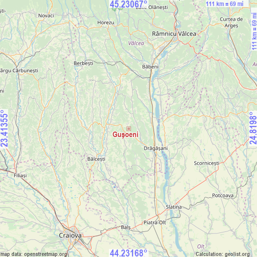
Guşoeni GPS coordinates[2]
44° 43' 59.988" North, 24° 7' 0.012" East
| Map corner | latitude | longitude |
|---|---|---|
| Upper-left | 45.23067°, | 23.41355° |
| Center: | 44.73333°, | 24.11667° |
| Lower-right: | 44.23168°, | 24.8198° |
| Map W x H: | 111.1×111.1 km | = 69×69mi |
| max Lat: | 48.23793° ⇑79% North |
| Guşoeni: | 44.73333° |
| min Lat: | ⇓21% South 43.65638° |
| min Long | Guşoeni | max Long |
| 20.31667° | 24.11667° | 29.65403° |
| W 32.5%⇐ | ⇒67.5% E |
Elevation
Elevation of Guşoeni is 225 m = 738 ft, and this is 29.9 m = 98 ft below average elevation for this country.
| Max E: |
1278 m = 4193 ft | 47.4% |
| Avg. | 254.9 m = 836 ft | |
| Guşoeni | 225 m = 738 ft | |
Min E: |
-2 m = -7 ft | 52.6% |
See also: Romania elevation on elevation.city.
Geographical zone
Guşoeni is located in North temperate zone (between Tropic of Cancer and the Arctic Circle). Distance of this Northern Tropic circle is 2368 km =1471.4 mi to South.| Distance of | km | miles | from Guşoeni |
|---|---|---|---|
| North Pole | 5033.2 | 3127.5 | to North |
| Arctic Circle | 2427.3 | 1508.3 | to North |
| Tropic Cancer | 2368 | 1471.4 | to South |
| Equator | 4973.9 | 3090.6 | to South |


Nearby cities:
15 places around Guşoeni: (largest is in red/bold)
• Amărăşti
4.5 km =2.8 mi,  35°
35°
• Batârăşti
9.6 km =6 mi,  15°
15°
• Botorani
6.2 km =3.9 mi,  282°
282°
• Creţeni
7.7 km =4.8 mi,  136°
136°
• Drăganu
9.3 km =5.8 mi,  255°
255°
• Glăvile
9.6 km =6 mi, 15°
• Izvoru
4.5 km =2.8 mi,  95°
95°
• Mitrofani
7.3 km =4.5 mi,  90°
90°
• Mrenești
6 km =3.7 mi,  116°
116°
• Mădulari
6.9 km =4.3 mi,  191°
191°
• Nemoiu
4.1 km =2.5 mi,  72°
72°
• Olteanca
8.6 km =5.3 mi,  356°
356°
• Oveselu
8.1 km =5 mi, 283°
• Spârleni
3.7 km =2.3 mi,  152°
152°
• Streminoasa
7.3 km =4.5 mi, 137°
Sources, notices
• [Note1] Compared only with cities in Romania existing in our database
• [Src1] Map data: © OpenStreetMap contributors (CC-BY-SA)
• [Src2] Other city data from geonames.org with taken over terms of usage.
• [Src3] Geographical zone / Annual Mean Temperature by Robert A. Rohde @ Wikipedia
