Gura Teghii geodata
Gura Teghii (Buzău) is a seat of a second-order administrative division; located in Romania in Europe/Bucharest (GMT+3) time zone. With population of 3,835 people, there are 1240 cities with bigger population in this country. Compared to other cities in Romania, 55.7% of cities are located further ↑North; 71% of cities are located further ←West and 89.6% of cities have lower elevation than Gura Teghii. Note1


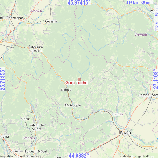
Gura Teghii GPS coordinates[2]
45° 28' 59.988" North, 26° 25' 0.012" East
| Map corner | latitude | longitude |
|---|---|---|
| Upper-left | 45.97415°, | 25.71355° |
| Center: | 45.48333°, | 26.41667° |
| Lower-right: | 44.9882°, | 27.1198° |
| Map W x H: | 109.6×109.6 km | = 68.1×68.1mi |
| max Lat: | 48.23793° ⇑55.7% North |
| Gura Teghii: | 45.48333° |
| min Lat: | ⇓44.3% South 43.65638° |
| min Long | Gura Teghii | max Long |
| 20.31667° | 26.41667° | 29.65403° |
| W 71%⇐ | ⇒29% E |
Elevation
Elevation of Gura Teghii is 507 m = 1663 ft, and this is 252.1 m = 827 ft above average elevation for this country.
| Max E: |
1278 m = 4193 ft | 10.4% |
| Gura Teghii | 507 m 1663 ft | |
| Avg. | 254.9 m = 836 ft | |
Min E: |
-2 m = -7 ft | 89.6% |
See also: Romania elevation on elevation.city.
Geographical zone
Gura Teghii is located in North temperate zone (between Tropic of Cancer and the Arctic Circle). Distance of this North polar circle is 2343.9 km =1456.4 mi to North.| Distance of | km | miles | from Gura Teghii |
|---|---|---|---|
| North Pole | 4949.8 | 3075.7 | to North |
| Arctic Circle | 2343.9 | 1456.4 | to North |
| Tropic Cancer | 2451.4 | 1523.2 | to South |
| Equator | 5057.3 | 3142.5 | to South |


Nearby cities:
15 places around Gura Teghii: (largest is in red/bold)
• Brăeşti
8.6 km =5.3 mi,  130°
130°
• Brătilești
5.4 km =3.4 mi,  107°
107°
• Bâsca Rozilei
7 km =4.3 mi,  242°
242°
• Colţi
11.4 km =7.1 mi,  193°
193°
• Colțu Pietrii
10.7 km =6.6 mi,  260°
260°
• Furtunești
3 km =1.9 mi,  209°
209°
• Ivănețu
6.5 km =4 mi, 114°
• Lunca Priporului
9.8 km =6.1 mi, 239°
• Luncile
10 km =6.2 mi,  81°
81°
• Mușcelușa
11.3 km =7 mi,  265°
265°
• Plaiu Nucului
8.3 km =5.2 mi,  91°
91°
• Ploștina
8.6 km =5.3 mi,  65°
65°
• Păltiniș
4.1 km =2.5 mi, 236°
• Terca
10.5 km =6.5 mi,  63°
63°
• Varlaam
3.6 km =2.2 mi,  37°
37°
Sources, notices
• [Note1] Compared only with cities in Romania existing in our database
• [Src1] Map data: © OpenStreetMap contributors (CC-BY-SA)
• [Src2] Other city data from geonames.org with taken over terms of usage.
• [Src3] Geographical zone / Annual Mean Temperature by Robert A. Rohde @ Wikipedia
